You are here: Home > Network List > TA - USArray Transportable Network (new EarthScope stations) Stations List
> Station H21K Melozitna River, AK, USA > Earthquake Result Viewer
H21K Melozitna River, AK, USA - Earthquake Result Viewer
| Earthquake location: |
Solomon Islands |
| Earthquake latitude/longitude: |
-9.3/158.4 |
| Earthquake time(UTC): |
2015/07/10 (191) 04:12:41 GMT |
| Earthquake Depth: |
10 km |
| Earthquake Magnitude: |
6.7 MWW, 6.6 MWB, 6.7 MWC, 7.0 MI |
| Earthquake Catalog/Contributor: |
NEIC PDE/NEIC COMCAT |
|
| Network: |
TA USArray Transportable Network (new EarthScope stations) |
| Station: |
H21K Melozitna River, AK, USA |
| Lat/Lon: |
65.66 N/152.80 W |
| Elevation: |
520 m |
|
| Distance: |
82.9 deg |
| Az: |
18.309 deg |
| Baz: |
228.419 deg |
| Ray Param: |
0.04655441 |
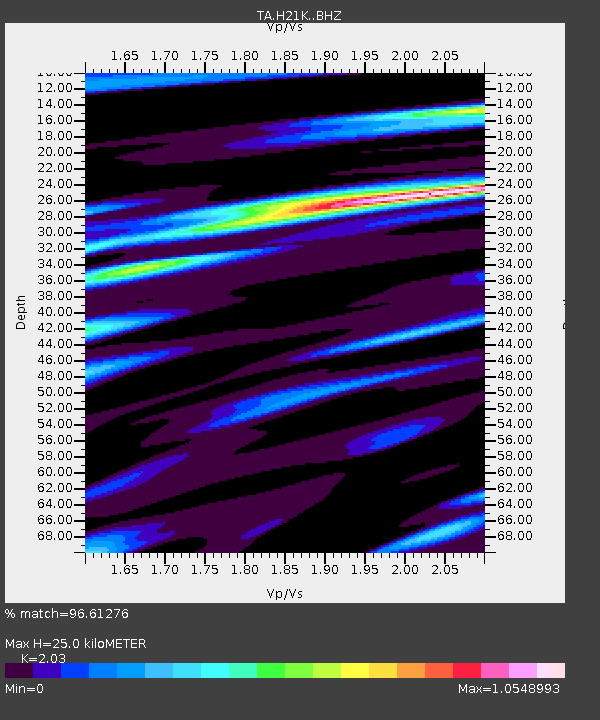
| Estimated Moho Depth: |
25.0 km |
| Estimated Crust Vp/Vs: |
2.03 |
| Assumed Crust Vp: |
6.566 km/s |
| Estimated Crust Vs: |
3.235 km/s |
| Estimated Crust Poisson's Ratio: |
0.34 |
|
| Radial Match: |
96.61276 % |
| Radial Bump: |
400 |
| Transverse Match: |
80.822655 % |
| Transverse Bump: |
400 |
| SOD ConfigId: |
7422571 |
| Insert Time: |
2019-04-19 18:26:58.162 +0000 |
| GWidth: |
2.5 |
| Max Bumps: |
400 |
| Tol: |
0.001 |
|

Signal To Noise
| Channel | StoN | STA | LTA |
| TA:H21K: :BHZ:20150710T04:24:35.124988Z | 14.752063 | 1.065902E-6 | 7.225444E-8 |
| TA:H21K: :BHN:20150710T04:24:35.124988Z | 3.895417 | 1.6471004E-7 | 4.2283034E-8 |
| TA:H21K: :BHE:20150710T04:24:35.124988Z | 4.191619 | 2.1984219E-7 | 5.2448037E-8 |
| Arrivals |
| Ps | 4.0 SECOND |
| PpPs | 11 SECOND |
| PsPs/PpSs | 15 SECOND |


