You are here: Home > Network List > TA - USArray Transportable Network (new EarthScope stations) Stations List
> Station L19K White Mountain, AK, USA > Earthquake Result Viewer
L19K White Mountain, AK, USA - Earthquake Result Viewer
| Earthquake location: |
Solomon Islands |
| Earthquake latitude/longitude: |
-9.3/158.4 |
| Earthquake time(UTC): |
2015/07/10 (191) 04:12:41 GMT |
| Earthquake Depth: |
10 km |
| Earthquake Magnitude: |
6.7 MWW, 6.6 MWB, 6.7 MWC, 7.0 MI |
| Earthquake Catalog/Contributor: |
NEIC PDE/NEIC COMCAT |
|
| Network: |
TA USArray Transportable Network (new EarthScope stations) |
| Station: |
L19K White Mountain, AK, USA |
| Lat/Lon: |
62.18 N/154.85 W |
| Elevation: |
650 m |
|
| Distance: |
79.9 deg |
| Az: |
20.299 deg |
| Baz: |
226.877 deg |
| Ray Param: |
0.04864662 |
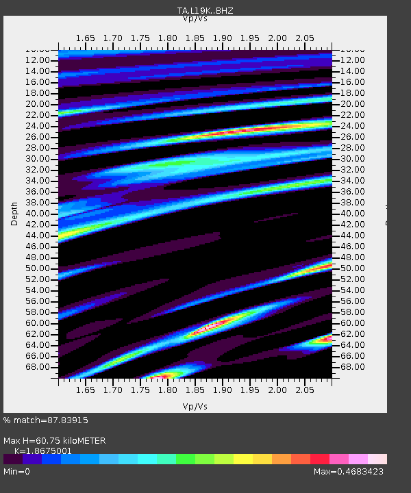
| Estimated Moho Depth: |
60.75 km |
| Estimated Crust Vp/Vs: |
1.87 |
| Assumed Crust Vp: |
6.438 km/s |
| Estimated Crust Vs: |
3.448 km/s |
| Estimated Crust Poisson's Ratio: |
0.30 |
|
| Radial Match: |
87.83915 % |
| Radial Bump: |
400 |
| Transverse Match: |
77.80798 % |
| Transverse Bump: |
400 |
| SOD ConfigId: |
7422571 |
| Insert Time: |
2019-04-19 18:27:06.474 +0000 |
| GWidth: |
2.5 |
| Max Bumps: |
400 |
| Tol: |
0.001 |
|

Signal To Noise
| Channel | StoN | STA | LTA |
| TA:L19K: :BHZ:20150710T04:24:19.225024Z | 13.648862 | 1.0474148E-6 | 7.6740086E-8 |
| TA:L19K: :BHN:20150710T04:24:19.225024Z | 3.5735855 | 2.3035814E-7 | 6.4461354E-8 |
| TA:L19K: :BHE:20150710T04:24:19.225024Z | 4.8237085 | 2.6269598E-7 | 5.4459335E-8 |
| Arrivals |
| Ps | 8.4 SECOND |
| PpPs | 26 SECOND |
| PsPs/PpSs | 35 SECOND |


