LTY Liberty (broad-band) - Earthquake Result Viewer
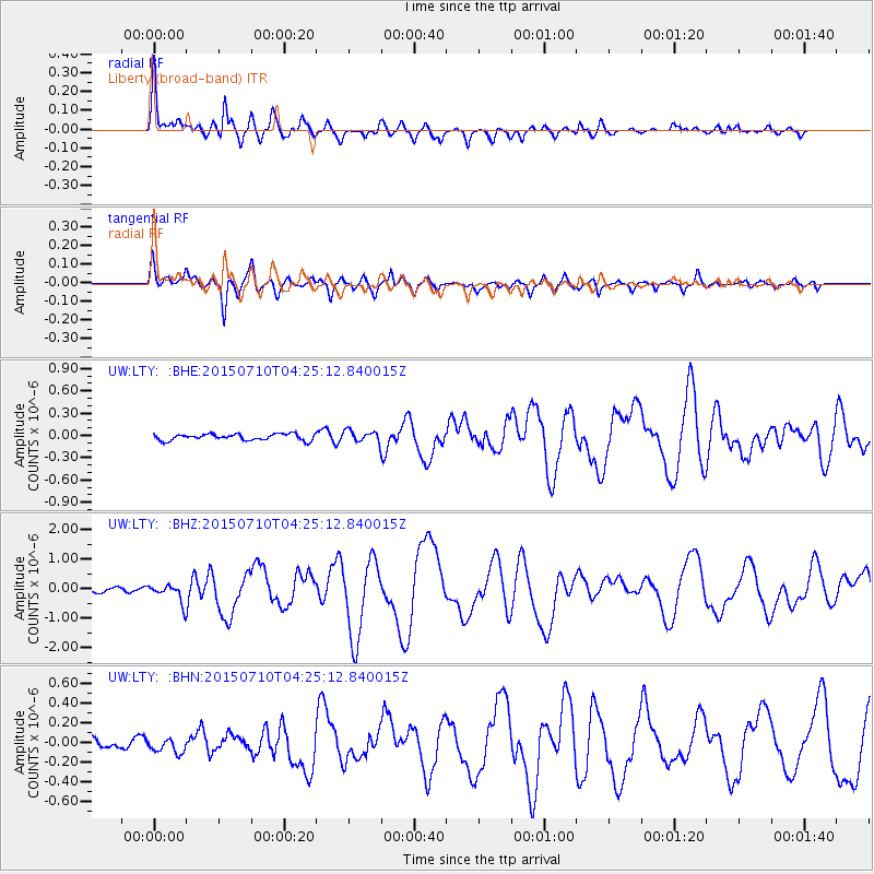
Earthquake location: Solomon Islands
Earthquake latitude/longitude: -9.3/158.4
Earthquake time(UTC): 2015/07/10 (191) 04:12:41 GMT
Earthquake Depth: 10 km
Earthquake Magnitude: 6.7 MWW, 6.6 MWB, 6.7 MWC, 7.0 MI
Earthquake Catalog/Contributor: NEIC PDE/NEIC COMCAT
Network: UW Pacific Northwest Regional Seismic Network
Station: LTY Liberty (broad-band)
Lat/Lon: 47.26 N/120.66 W
Elevation: 970 m
Distance: 90.7 deg
Az: 42.274 deg
Baz: 257.075 deg
Ray Param: 0.04165755
Estimated Moho Depth: 29.0 km
Estimated Crust Vp/Vs: 1.60
Assumed Crust Vp: 6.597 km/s
Estimated Crust Vs: 4.123 km/s
Estimated Crust Poisson's Ratio: 0.18
Radial Match: 90.413376 %
Radial Bump: 400
Transverse Match: 87.76181 %
Transverse Bump: 400
SOD ConfigId: 7422571
Insert Time: 2019-04-19 18:27:50.751 +0000
GWidth: 2.5
Max Bumps: 400
Tol: 0.001

Signal To Noise

ChannelStoNSTALTA
UW:LTY: :BHZ:20150710T04:25:12.840015Z2.8750293.0426924E-71.0583171E-7
UW:LTY: :BHN:20150710T04:25:12.840015Z1.4380376.940172E-84.826143E-8
UW:LTY: :BHE:20150710T04:25:12.840015Z2.2064079.39897E-84.2598526E-8
Arrivals
Ps2.7 SECOND
PpPs11 SECOND
PsPs/PpSs14 SECOND