You are here: Home > Network List > YT07 - POLENET Stations List
> Station WAIS WAIS > Earthquake Result Viewer
WAIS WAIS - Earthquake Result Viewer
| Earthquake location: |
Solomon Islands |
| Earthquake latitude/longitude: |
-9.3/158.4 |
| Earthquake time(UTC): |
2015/07/10 (191) 04:12:41 GMT |
| Earthquake Depth: |
10 km |
| Earthquake Magnitude: |
6.7 MWW, 6.6 MWB, 6.7 MWC, 7.0 MI |
| Earthquake Catalog/Contributor: |
NEIC PDE/NEIC COMCAT |
|
| Network: |
YT POLENET |
| Station: |
WAIS WAIS |
| Lat/Lon: |
79.42 S/111.78 W |
| Elevation: |
1800 m |
|
| Distance: |
80.9 deg |
| Az: |
169.21 deg |
| Baz: |
268.473 deg |
| Ray Param: |
0.047982853 |
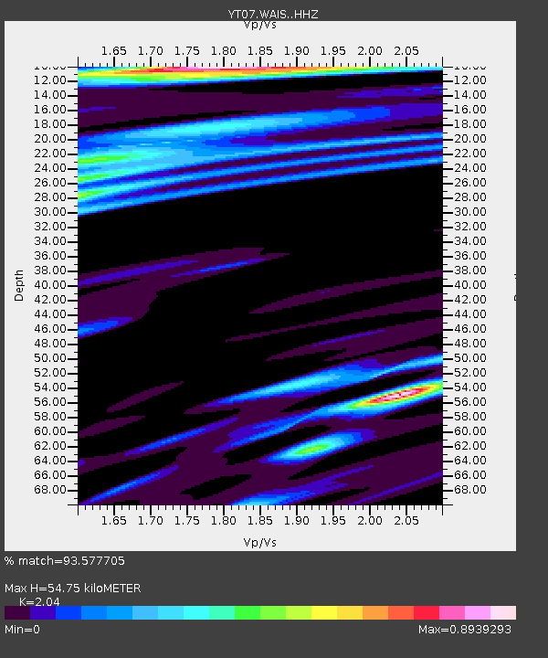
| Estimated Moho Depth: |
54.75 km |
| Estimated Crust Vp/Vs: |
2.04 |
| Assumed Crust Vp: |
5.833 km/s |
| Estimated Crust Vs: |
2.859 km/s |
| Estimated Crust Poisson's Ratio: |
0.34 |
|
| Radial Match: |
93.577705 % |
| Radial Bump: |
296 |
| Transverse Match: |
84.004364 % |
| Transverse Bump: |
400 |
| SOD ConfigId: |
7422571 |
| Insert Time: |
2019-04-19 18:29:37.198 +0000 |
| GWidth: |
2.5 |
| Max Bumps: |
400 |
| Tol: |
0.001 |
|

Signal To Noise
| Channel | StoN | STA | LTA |
| YT:WAIS: :HHZ:20150710T04:24:23.950Z | 2.74722 | 5.201523E-7 | 1.893377E-7 |
| YT:WAIS: :HHN:20150710T04:24:23.950Z | 0.9089826 | 9.4178624E-8 | 1.0360884E-7 |
| YT:WAIS: :HHE:20150710T04:24:23.950Z | 1.5404469 | 9.371087E-8 | 6.083356E-8 |
| Arrivals |
| Ps | 10.0 SECOND |
| PpPs | 28 SECOND |
| PsPs/PpSs | 38 SECOND |


