You are here: Home > Network List > ZJ12 - Transantarctic Mountains Northern Network Stations List
> Station MICH Tinker Glacier, Antarctica > Earthquake Result Viewer
MICH Tinker Glacier, Antarctica - Earthquake Result Viewer
| Earthquake location: |
Solomon Islands |
| Earthquake latitude/longitude: |
-9.3/158.4 |
| Earthquake time(UTC): |
2015/07/10 (191) 04:12:41 GMT |
| Earthquake Depth: |
10 km |
| Earthquake Magnitude: |
6.7 MWW, 6.6 MWB, 6.7 MWC, 7.0 MI |
| Earthquake Catalog/Contributor: |
NEIC PDE/NEIC COMCAT |
|
| Network: |
ZJ Transantarctic Mountains Northern Network |
| Station: |
MICH Tinker Glacier, Antarctica |
| Lat/Lon: |
73.82 S/164.10 E |
| Elevation: |
817 m |
|
| Distance: |
64.5 deg |
| Az: |
178.24 deg |
| Baz: |
353.793 deg |
| Ray Param: |
0.058851764 |
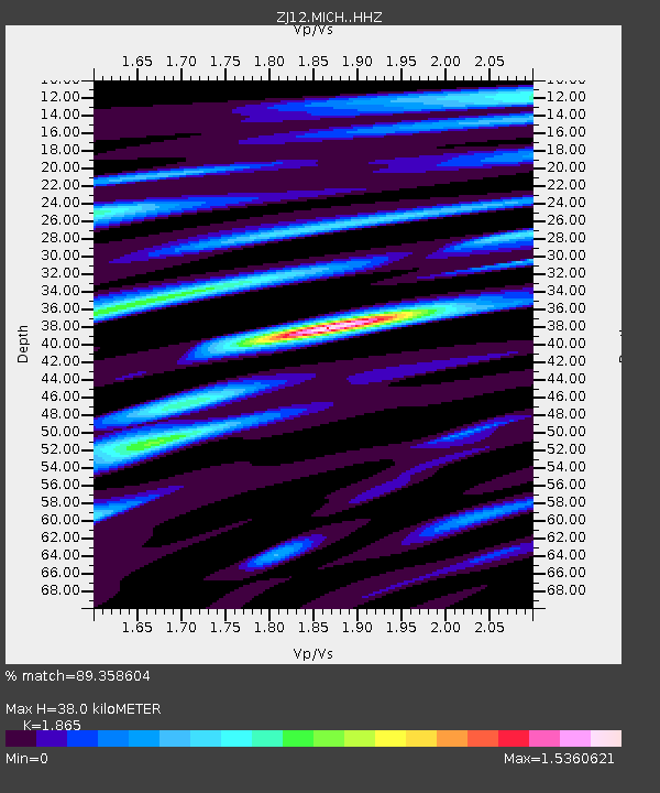
| Estimated Moho Depth: |
38.0 km |
| Estimated Crust Vp/Vs: |
1.87 |
| Assumed Crust Vp: |
6.245 km/s |
| Estimated Crust Vs: |
3.348 km/s |
| Estimated Crust Poisson's Ratio: |
0.30 |
|
| Radial Match: |
89.358604 % |
| Radial Bump: |
400 |
| Transverse Match: |
78.189 % |
| Transverse Bump: |
400 |
| SOD ConfigId: |
7422571 |
| Insert Time: |
2019-04-19 18:29:44.189 +0000 |
| GWidth: |
2.5 |
| Max Bumps: |
400 |
| Tol: |
0.001 |
|

Signal To Noise
| Channel | StoN | STA | LTA |
| ZJ:MICH: :HHZ:20150710T04:22:47.148975Z | 2.3600974 | 4.774834E-7 | 2.023151E-7 |
| ZJ:MICH: :HHN:20150710T04:22:47.148975Z | 0.54273427 | 1.0863176E-7 | 2.0015645E-7 |
| ZJ:MICH: :HHE:20150710T04:22:47.148975Z | 2.0135386 | 2.9736262E-7 | 1.476816E-7 |
| Arrivals |
| Ps | 5.5 SECOND |
| PpPs | 17 SECOND |
| PsPs/PpSs | 22 SECOND |


