You are here: Home > Network List > TA - USArray Transportable Network (new EarthScope stations) Stations List
> Station D58A Chemin du LacGrosbois, Trois-Rives, QC, CAN > Earthquake Result Viewer
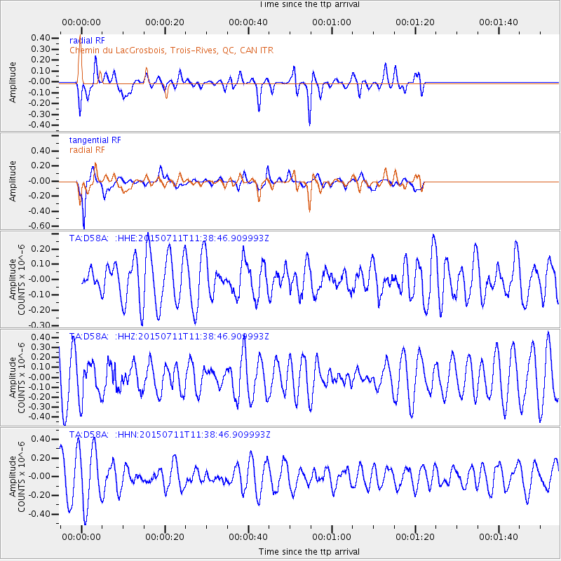
D58A Chemin du LacGrosbois, Trois-Rives, QC, CAN - Earthquake Result Viewer
*The percent match for this event was below the threshold and hence no stack was calculated.
| Earthquake location: |
East Of Kuril Islands |
| Earthquake latitude/longitude: |
43.9/148.0 |
| Earthquake time(UTC): |
2015/07/11 (192) 11:26:59 GMT |
| Earthquake Depth: |
32 km |
| Earthquake Magnitude: |
5.5 MB |
| Earthquake Catalog/Contributor: |
NEIC PDE/NEIC COMCAT |
|
| Network: |
TA USArray Transportable Network (new EarthScope stations) |
| Station: |
D58A Chemin du LacGrosbois, Trois-Rives, QC, CAN |
| Lat/Lon: |
47.10 N/72.88 W |
| Elevation: |
398 m |
|
| Distance: |
82.5 deg |
| Az: |
26.828 deg |
| Baz: |
331.478 deg |
| Ray Param: |
$rayparam |
*The percent match for this event was below the threshold and hence was not used in the summary stack. |
|
| Radial Match: |
55.539654 % |
| Radial Bump: |
400 |
| Transverse Match: |
81.82861 % |
| Transverse Bump: |
364 |
| SOD ConfigId: |
7422571 |
| Insert Time: |
2019-04-19 18:52:39.803 +0000 |
| GWidth: |
2.5 |
| Max Bumps: |
400 |
| Tol: |
0.001 |
|
Signal To Noise
| Channel | StoN | STA | LTA |
| TA:D58A: :HHZ:20150711T11:38:46.909993Z | 1.1426189 | 1.8666863E-7 | 1.6336911E-7 |
| TA:D58A: :HHN:20150711T11:38:46.909993Z | 2.2508187 | 3.1302608E-7 | 1.390721E-7 |
| TA:D58A: :HHE:20150711T11:38:46.909993Z | 0.7289358 | 1.0218725E-7 | 1.401869E-7 |
| Arrivals |
| Ps | |
| PpPs | |
| PsPs/PpSs | |


