You are here: Home > Network List > TA - USArray Transportable Network (new EarthScope stations) Stations List
> Station E64A Bridgewater, ME, USA > Earthquake Result Viewer
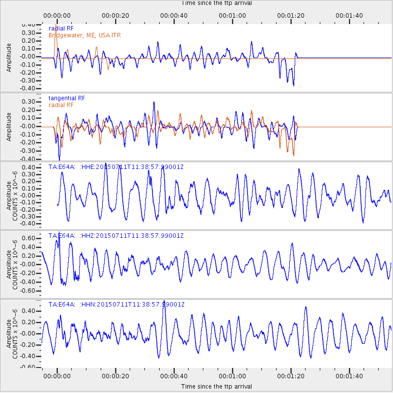
E64A Bridgewater, ME, USA - Earthquake Result Viewer
*The percent match for this event was below the threshold and hence no stack was calculated.
| Earthquake location: |
East Of Kuril Islands |
| Earthquake latitude/longitude: |
43.9/148.0 |
| Earthquake time(UTC): |
2015/07/11 (192) 11:26:59 GMT |
| Earthquake Depth: |
32 km |
| Earthquake Magnitude: |
5.5 MB |
| Earthquake Catalog/Contributor: |
NEIC PDE/NEIC COMCAT |
|
| Network: |
TA USArray Transportable Network (new EarthScope stations) |
| Station: |
E64A Bridgewater, ME, USA |
| Lat/Lon: |
46.42 N/67.83 W |
| Elevation: |
190 m |
|
| Distance: |
84.6 deg |
| Az: |
24.016 deg |
| Baz: |
334.833 deg |
| Ray Param: |
$rayparam |
*The percent match for this event was below the threshold and hence was not used in the summary stack. |
|
| Radial Match: |
50.30264 % |
| Radial Bump: |
400 |
| Transverse Match: |
76.28727 % |
| Transverse Bump: |
400 |
| SOD ConfigId: |
7422571 |
| Insert Time: |
2019-04-19 18:52:42.180 +0000 |
| GWidth: |
2.5 |
| Max Bumps: |
400 |
| Tol: |
0.001 |
|
Signal To Noise
| Channel | StoN | STA | LTA |
| TA:E64A: :HHZ:20150711T11:38:57.99001Z | 1.6562881 | 4.142823E-7 | 2.5012696E-7 |
| TA:E64A: :HHN:20150711T11:38:57.99001Z | 1.2579345 | 1.7338297E-7 | 1.3783149E-7 |
| TA:E64A: :HHE:20150711T11:38:57.99001Z | 1.1493808 | 2.3052019E-7 | 2.0056032E-7 |
| Arrivals |
| Ps | |
| PpPs | |
| PsPs/PpSs | |


