You are here: Home > Network List > US - United States National Seismic Network Stations List
> Station LAO LASA Array, Montana, USA > Earthquake Result Viewer
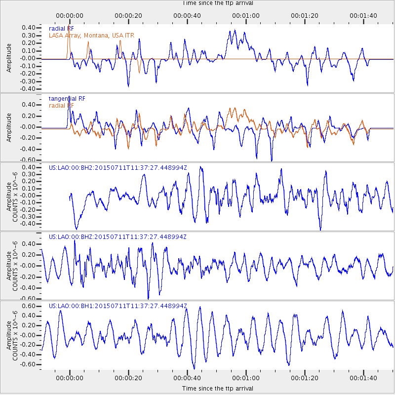
LAO LASA Array, Montana, USA - Earthquake Result Viewer
*The percent match for this event was below the threshold and hence no stack was calculated.
| Earthquake location: |
East Of Kuril Islands |
| Earthquake latitude/longitude: |
43.9/148.0 |
| Earthquake time(UTC): |
2015/07/11 (192) 11:26:59 GMT |
| Earthquake Depth: |
32 km |
| Earthquake Magnitude: |
5.5 MB |
| Earthquake Catalog/Contributor: |
NEIC PDE/NEIC COMCAT |
|
| Network: |
US United States National Seismic Network |
| Station: |
LAO LASA Array, Montana, USA |
| Lat/Lon: |
46.69 N/106.22 W |
| Elevation: |
902 m |
|
| Distance: |
68.5 deg |
| Az: |
45.396 deg |
| Baz: |
311.615 deg |
| Ray Param: |
$rayparam |
*The percent match for this event was below the threshold and hence was not used in the summary stack. |
|
| Radial Match: |
55.3694 % |
| Radial Bump: |
400 |
| Transverse Match: |
61.115566 % |
| Transverse Bump: |
400 |
| SOD ConfigId: |
7422571 |
| Insert Time: |
2019-04-19 18:53:32.842 +0000 |
| GWidth: |
2.5 |
| Max Bumps: |
400 |
| Tol: |
0.001 |
|
Signal To Noise
| Channel | StoN | STA | LTA |
| US:LAO:00:BHZ:20150711T11:37:27.448994Z | 1.5759953 | 2.3130603E-7 | 1.4676823E-7 |
| US:LAO:00:BH1:20150711T11:37:27.448994Z | 0.38135025 | 1.0162427E-7 | 2.664854E-7 |
| US:LAO:00:BH2:20150711T11:37:27.448994Z | 0.7489848 | 1.0572872E-7 | 1.4116269E-7 |
| Arrivals |
| Ps | |
| PpPs | |
| PsPs/PpSs | |


