You are here: Home > Network List > TA - USArray Transportable Network (new EarthScope stations) Stations List
> Station I23K Minto, Yukon-Koyukuk, AK, USA > Earthquake Result Viewer
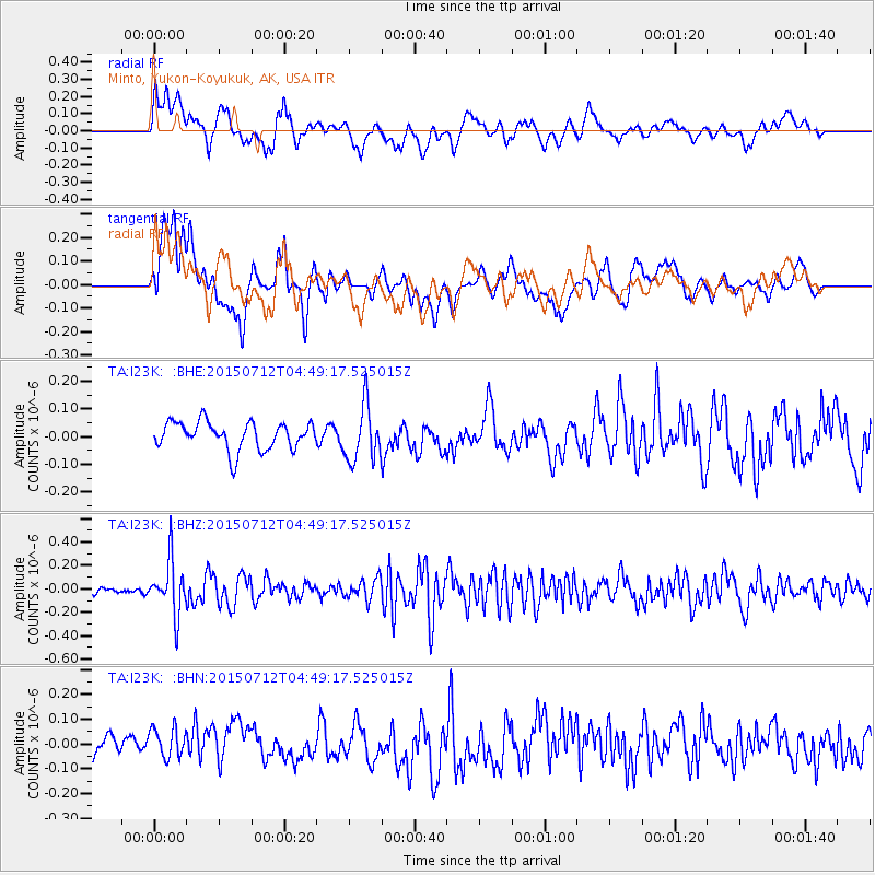
I23K Minto, Yukon-Koyukuk, AK, USA - Earthquake Result Viewer
*The percent match for this event was below the threshold and hence no stack was calculated.
| Earthquake location: |
Halmahera, Indonesia |
| Earthquake latitude/longitude: |
2.9/128.2 |
| Earthquake time(UTC): |
2015/07/12 (193) 04:37:31 GMT |
| Earthquake Depth: |
128 km |
| Earthquake Magnitude: |
5.6 MW |
| Earthquake Catalog/Contributor: |
ISC/ISC |
|
| Network: |
TA USArray Transportable Network (new EarthScope stations) |
| Station: |
I23K Minto, Yukon-Koyukuk, AK, USA |
| Lat/Lon: |
65.15 N/149.36 W |
| Elevation: |
149 m |
|
| Distance: |
84.2 deg |
| Az: |
24.903 deg |
| Baz: |
264.337 deg |
| Ray Param: |
$rayparam |
*The percent match for this event was below the threshold and hence was not used in the summary stack. |
|
| Radial Match: |
63.728065 % |
| Radial Bump: |
400 |
| Transverse Match: |
65.26321 % |
| Transverse Bump: |
400 |
| SOD ConfigId: |
7422571 |
| Insert Time: |
2019-04-19 19:00:34.085 +0000 |
| GWidth: |
2.5 |
| Max Bumps: |
400 |
| Tol: |
0.001 |
|
Signal To Noise
| Channel | StoN | STA | LTA |
| TA:I23K: :BHZ:20150712T04:49:17.525015Z | 3.9439073 | 2.2584607E-7 | 5.726455E-8 |
| TA:I23K: :BHN:20150712T04:49:17.525015Z | 1.1162405 | 6.615162E-8 | 5.9262874E-8 |
| TA:I23K: :BHE:20150712T04:49:17.525015Z | 2.026889 | 1.008126E-7 | 4.9737597E-8 |
| Arrivals |
| Ps | |
| PpPs | |
| PsPs/PpSs | |


