You are here: Home > Network List > IU - Global Seismograph Network (GSN - IRIS/USGS) Stations List
> Station FURI Mt. Furi, Ethiopia > Earthquake Result Viewer
FURI Mt. Furi, Ethiopia - Earthquake Result Viewer

| Earthquake location: |
Sunda Strait, Indonesia |
| Earthquake latitude/longitude: |
-7.0/104.2 |
| Earthquake time(UTC): |
2002/06/27 (178) 05:50:35 GMT |
| Earthquake Depth: |
11 km |
| Earthquake Magnitude: |
6.0 MB, 6.9 MS, 6.6 MW, 6.5 MW |
| Earthquake Catalog/Contributor: |
WHDF/NEIC |
|
| Network: |
IU Global Seismograph Network (GSN - IRIS/USGS) |
| Station: |
FURI Mt. Furi, Ethiopia |
| Lat/Lon: |
8.90 N/38.68 E |
| Elevation: |
2570 m |
|
| Distance: |
67.2 deg |
| Az: |
282.652 deg |
| Baz: |
101.405 deg |
| Ray Param: |
0.05714007 |
| Estimated Moho Depth: |
14.75 km |
| Estimated Crust Vp/Vs: |
1.61 |
| Assumed Crust Vp: |
6.464 km/s |
| Estimated Crust Vs: |
4.021 km/s |
| Estimated Crust Poisson's Ratio: |
0.18 |
|
| Radial Match: |
95.08798 % |
| Radial Bump: |
316 |
| Transverse Match: |
85.642006 % |
| Transverse Bump: |
400 |
| SOD ConfigId: |
20082 |
| Insert Time: |
2010-03-03 16:23:27.122 +0000 |
| GWidth: |
2.5 |
| Max Bumps: |
400 |
| Tol: |
0.001 |
|
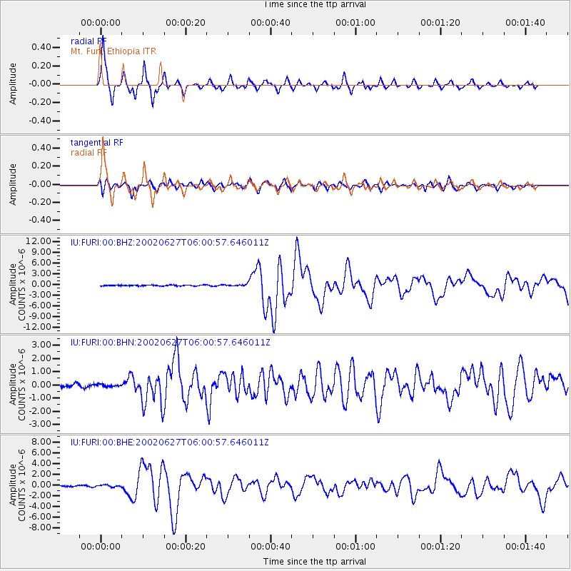
Signal To Noise
| Channel | StoN | STA | LTA |
| IU:FURI:00:BHN:20020627T06:00:57.646011Z | 0.62546927 | 8.657413E-8 | 1.3841469E-7 |
| IU:FURI:00:BHE:20020627T06:00:57.646011Z | 1.3276405 | 1.6887202E-7 | 1.271971E-7 |
| IU:FURI:00:BHZ:20020627T06:00:57.646011Z | 2.2190394 | 2.9488166E-7 | 1.3288707E-7 |
| Arrivals |
| Ps | 1.4 SECOND |
| PpPs | 5.7 SECOND |
| PsPs/PpSs | 7.1 SECOND |


