You are here: Home > Network List > IU - Global Seismograph Network (GSN - IRIS/USGS) Stations List
> Station FURI Mt. Furi, Ethiopia > Earthquake Result Viewer
FURI Mt. Furi, Ethiopia - Earthquake Result Viewer
| Earthquake location: |
Samar, Philippines |
| Earthquake latitude/longitude: |
12.2/124.1 |
| Earthquake time(UTC): |
2003/02/15 (046) 11:01:59 GMT |
| Earthquake Depth: |
10 km |
| Earthquake Magnitude: |
5.8 MB, 6.2 MS, 6.3 MW, 6.2 MW |
| Earthquake Catalog/Contributor: |
WHDF/NEIC |
|
| Network: |
IU Global Seismograph Network (GSN - IRIS/USGS) |
| Station: |
FURI Mt. Furi, Ethiopia |
| Lat/Lon: |
8.90 N/38.68 E |
| Elevation: |
2570 m |
|
| Distance: |
83.7 deg |
| Az: |
277.725 deg |
| Baz: |
78.692 deg |
| Ray Param: |
0.045999177 |
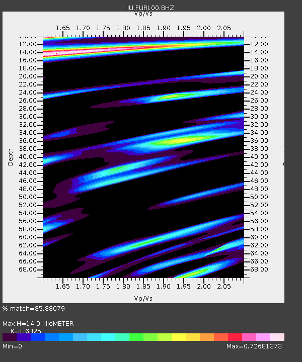
| Estimated Moho Depth: |
14.0 km |
| Estimated Crust Vp/Vs: |
1.63 |
| Assumed Crust Vp: |
6.464 km/s |
| Estimated Crust Vs: |
3.959 km/s |
| Estimated Crust Poisson's Ratio: |
0.20 |
|
| Radial Match: |
85.88079 % |
| Radial Bump: |
400 |
| Transverse Match: |
86.926315 % |
| Transverse Bump: |
387 |
| SOD ConfigId: |
4714 |
| Insert Time: |
2010-03-03 16:23:36.602 +0000 |
| GWidth: |
2.5 |
| Max Bumps: |
400 |
| Tol: |
0.001 |
|

Signal To Noise
| Channel | StoN | STA | LTA |
| IU:FURI:00:BHN:20030215T11:13:57.263015Z | 1.1302145 | 1.5323094E-7 | 1.3557687E-7 |
| IU:FURI:00:BHE:20030215T11:13:57.263015Z | 1.0988201 | 1.724784E-7 | 1.5696692E-7 |
| IU:FURI:00:BHZ:20030215T11:13:57.263015Z | 0.9867439 | 1.1869812E-7 | 1.2029273E-7 |
| Arrivals |
| Ps | 1.4 SECOND |
| PpPs | 5.5 SECOND |
| PsPs/PpSs | 7.0 SECOND |


