You are here: Home > Network List > IU - Global Seismograph Network (GSN - IRIS/USGS) Stations List
> Station FURI Mt. Furi, Ethiopia > Earthquake Result Viewer
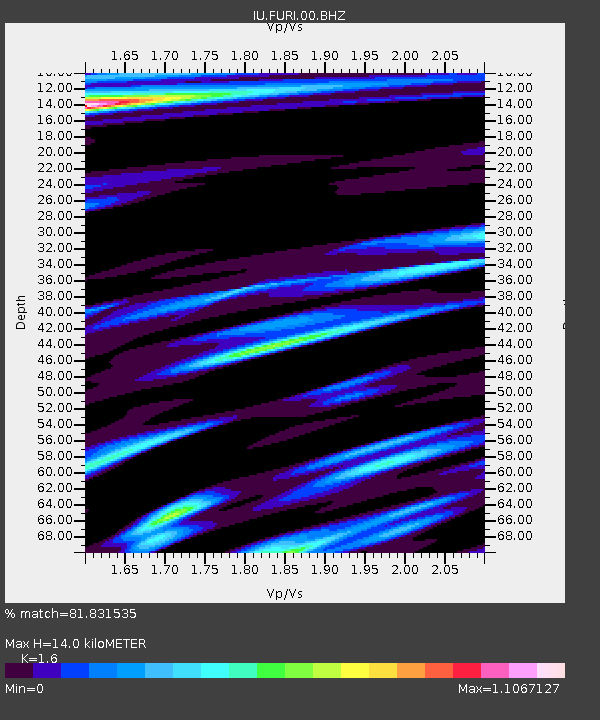
FURI Mt. Furi, Ethiopia - Earthquake Result Viewer
| Earthquake location: |
Halmahera, Indonesia |
| Earthquake latitude/longitude: |
1.7/127.3 |
| Earthquake time(UTC): |
2003/03/10 (069) 02:09:37 GMT |
| Earthquake Depth: |
94 km |
| Earthquake Magnitude: |
6.2 MB, 6.4 MW, 6.4 MW |
| Earthquake Catalog/Contributor: |
WHDF/NEIC |
|
| Network: |
IU Global Seismograph Network (GSN - IRIS/USGS) |
| Station: |
FURI Mt. Furi, Ethiopia |
| Lat/Lon: |
8.90 N/38.68 E |
| Elevation: |
2570 m |
|
| Distance: |
88.4 deg |
| Az: |
278.796 deg |
| Baz: |
88.551 deg |
| Ray Param: |
0.042441163 |
| Estimated Moho Depth: |
14.0 km |
| Estimated Crust Vp/Vs: |
1.60 |
| Assumed Crust Vp: |
6.464 km/s |
| Estimated Crust Vs: |
4.04 km/s |
| Estimated Crust Poisson's Ratio: |
0.18 |
|
| Radial Match: |
81.831535 % |
| Radial Bump: |
400 |
| Transverse Match: |
81.50515 % |
| Transverse Bump: |
400 |
| SOD ConfigId: |
4714 |
| Insert Time: |
2010-03-03 16:23:38.762 +0000 |
| GWidth: |
2.5 |
| Max Bumps: |
400 |
| Tol: |
0.001 |
|

Signal To Noise
| Channel | StoN | STA | LTA |
| IU:FURI:00:BHN:20030310T02:21:47.269026Z | 0.61697835 | 8.094763E-8 | 1.3120012E-7 |
| IU:FURI:00:BHE:20030310T02:21:47.269026Z | 0.95574385 | 1.002979E-7 | 1.0494224E-7 |
| IU:FURI:00:BHZ:20030310T02:21:47.269026Z | 1.0980213 | 1.4630571E-7 | 1.3324488E-7 |
| Arrivals |
| Ps | 1.3 SECOND |
| PpPs | 5.5 SECOND |
| PsPs/PpSs | 6.8 SECOND |


