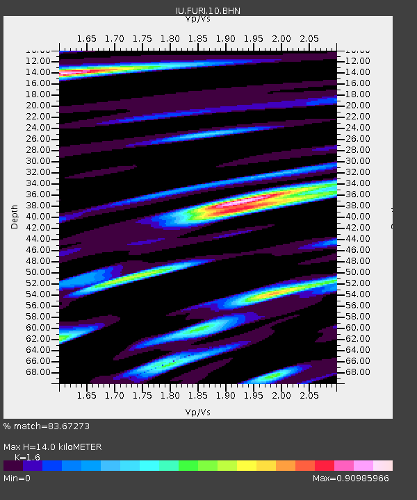
FURI Mt. Furi, Ethiopia - Earthquake Result Viewer

Earthquake location: Near S. Coast Of Honshu, Japan
Earthquake latitude/longitude: 33.1/137.2
Earthquake time(UTC): 2004/09/08 (252) 14:58:25 GMT
Earthquake Depth: 21 km
Earthquake Magnitude: 6.2 MB, 5.8 MS, 6.2 MW, 6.1 MW
Earthquake Catalog/Contributor: WHDF/NEIC
Network: IU Global Seismograph Network (GSN - IRIS/USGS)
Station: FURI Mt. Furi, Ethiopia
Lat/Lon: 8.90 N/38.68 E
Elevation: 2570 m
Distance: 92.2 deg
Az: 282.046 deg
Baz: 56.139 deg
Ray Param: 0.04148293
Estimated Moho Depth: 14.0 km
Estimated Crust Vp/Vs: 1.60
Assumed Crust Vp: 6.464 km/s
Estimated Crust Vs: 4.04 km/s
Estimated Crust Poisson's Ratio: 0.18
Radial Match: 83.67273 %
Radial Bump: 400
Transverse Match: 87.65808 %
Transverse Bump: 400
SOD ConfigId: 2459
Insert Time: 2010-03-03 16:23:40.751 +0000
GWidth: 2.5
Max Bumps: 400
Tol: 0.001

Signal To Noise

ChannelStoNSTALTA
IU:FURI:10:BHN:20040908T15:11:02.473005Z0.944124341.412863E-71.4964799E-7
IU:FURI:10:BHE:20040908T15:11:02.473005Z1.43636361.488171E-71.0360684E-7
IU:FURI:10:BHZ:20040908T15:11:02.473005Z2.88409073.0893017E-71.0711527E-7
Arrivals
Ps1.3 SECOND
PpPs5.5 SECOND
PsPs/PpSs6.8 SECOND