You are here: Home > Network List > IU - Global Seismograph Network (GSN - IRIS/USGS) Stations List
> Station FURI Mt. Furi, Ethiopia > Earthquake Result Viewer
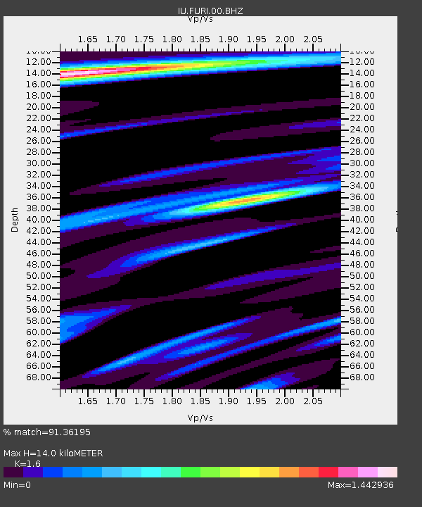
FURI Mt. Furi, Ethiopia - Earthquake Result Viewer
| Earthquake location: |
Taiwan Region |
| Earthquake latitude/longitude: |
24.5/122.7 |
| Earthquake time(UTC): |
2004/10/15 (289) 04:08:50 GMT |
| Earthquake Depth: |
94 km |
| Earthquake Magnitude: |
6.4 MB, 6.7 MW, 6.6 MW |
| Earthquake Catalog/Contributor: |
WHDF/NEIC |
|
| Network: |
IU Global Seismograph Network (GSN - IRIS/USGS) |
| Station: |
FURI Mt. Furi, Ethiopia |
| Lat/Lon: |
8.90 N/38.68 E |
| Elevation: |
2570 m |
|
| Distance: |
81.0 deg |
| Az: |
275.658 deg |
| Baz: |
66.526 deg |
| Ray Param: |
0.047720715 |
| Estimated Moho Depth: |
14.0 km |
| Estimated Crust Vp/Vs: |
1.60 |
| Assumed Crust Vp: |
6.464 km/s |
| Estimated Crust Vs: |
4.04 km/s |
| Estimated Crust Poisson's Ratio: |
0.18 |
|
| Radial Match: |
91.36195 % |
| Radial Bump: |
400 |
| Transverse Match: |
83.83801 % |
| Transverse Bump: |
400 |
| SOD ConfigId: |
2459 |
| Insert Time: |
2010-03-03 16:23:48.826 +0000 |
| GWidth: |
2.5 |
| Max Bumps: |
400 |
| Tol: |
0.001 |
|

Signal To Noise
| Channel | StoN | STA | LTA |
| IU:FURI:00:BHN:20041015T04:20:23.234995Z | 0.63097 | 7.9743536E-8 | 1.2638245E-7 |
| IU:FURI:00:BHE:20041015T04:20:23.234995Z | 1.2660573 | 1.06010454E-7 | 8.373274E-8 |
| IU:FURI:00:BHZ:20041015T04:20:23.234995Z | 3.1976748 | 2.5101068E-7 | 7.849788E-8 |
| Arrivals |
| Ps | 1.3 SECOND |
| PpPs | 5.5 SECOND |
| PsPs/PpSs | 6.8 SECOND |


