You are here: Home > Network List > IU - Global Seismograph Network (GSN - IRIS/USGS) Stations List
> Station FURI Mt. Furi, Ethiopia > Earthquake Result Viewer
FURI Mt. Furi, Ethiopia - Earthquake Result Viewer

| Earthquake location: |
Taiwan Region |
| Earthquake latitude/longitude: |
22.7/121.5 |
| Earthquake time(UTC): |
2004/05/19 (140) 07:04:11 GMT |
| Earthquake Depth: |
20 km |
| Earthquake Magnitude: |
5.8 MB, 6.1 MS, 6.2 MW, 6.1 MW |
| Earthquake Catalog/Contributor: |
WHDF/NEIC |
|
| Network: |
IU Global Seismograph Network (GSN - IRIS/USGS) |
| Station: |
FURI Mt. Furi, Ethiopia |
| Lat/Lon: |
8.90 N/38.68 E |
| Elevation: |
2570 m |
|
| Distance: |
80.0 deg |
| Az: |
275.513 deg |
| Baz: |
68.51 deg |
| Ray Param: |
0.04852599 |
| Estimated Moho Depth: |
69.25 km |
| Estimated Crust Vp/Vs: |
1.96 |
| Assumed Crust Vp: |
6.464 km/s |
| Estimated Crust Vs: |
3.294 km/s |
| Estimated Crust Poisson's Ratio: |
0.32 |
|
| Radial Match: |
80.25842 % |
| Radial Bump: |
400 |
| Transverse Match: |
74.88041 % |
| Transverse Bump: |
400 |
| SOD ConfigId: |
2459 |
| Insert Time: |
2010-03-03 16:23:51.730 +0000 |
| GWidth: |
2.5 |
| Max Bumps: |
400 |
| Tol: |
0.001 |
|
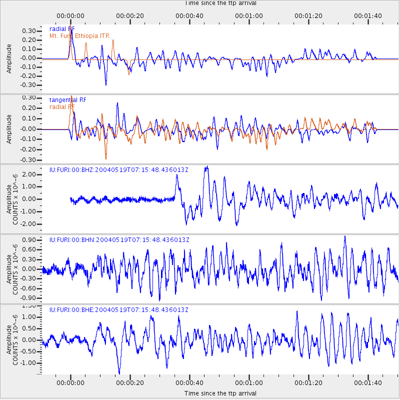
Signal To Noise
| Channel | StoN | STA | LTA |
| IU:FURI:00:BHN:20040519T07:15:48.436013Z | 1.3662778 | 1.8387568E-7 | 1.3458148E-7 |
| IU:FURI:00:BHE:20040519T07:15:48.436013Z | 0.9874101 | 1.3932089E-7 | 1.4109729E-7 |
| IU:FURI:00:BHZ:20040519T07:15:48.436013Z | 0.74028623 | 1.00062955E-7 | 1.3516792E-7 |
| Arrivals |
| Ps | 11 SECOND |
| PpPs | 31 SECOND |
| PsPs/PpSs | 42 SECOND |


