You are here: Home > Network List > IU - Global Seismograph Network (GSN - IRIS/USGS) Stations List
> Station FURI Mt. Furi, Ethiopia > Earthquake Result Viewer
FURI Mt. Furi, Ethiopia - Earthquake Result Viewer
| Earthquake location: |
South Indian Ocean |
| Earthquake latitude/longitude: |
-36.7/53.4 |
| Earthquake time(UTC): |
2004/01/11 (011) 04:32:47 GMT |
| Earthquake Depth: |
5.3 km |
| Earthquake Magnitude: |
6.1 MB, 6.1 MS, 6.2 MW, 6.2 MW |
| Earthquake Catalog/Contributor: |
WHDF/NEIC |
|
| Network: |
IU Global Seismograph Network (GSN - IRIS/USGS) |
| Station: |
FURI Mt. Furi, Ethiopia |
| Lat/Lon: |
8.90 N/38.68 E |
| Elevation: |
2570 m |
|
| Distance: |
47.4 deg |
| Az: |
340.122 deg |
| Baz: |
163.944 deg |
| Ray Param: |
0.07002871 |
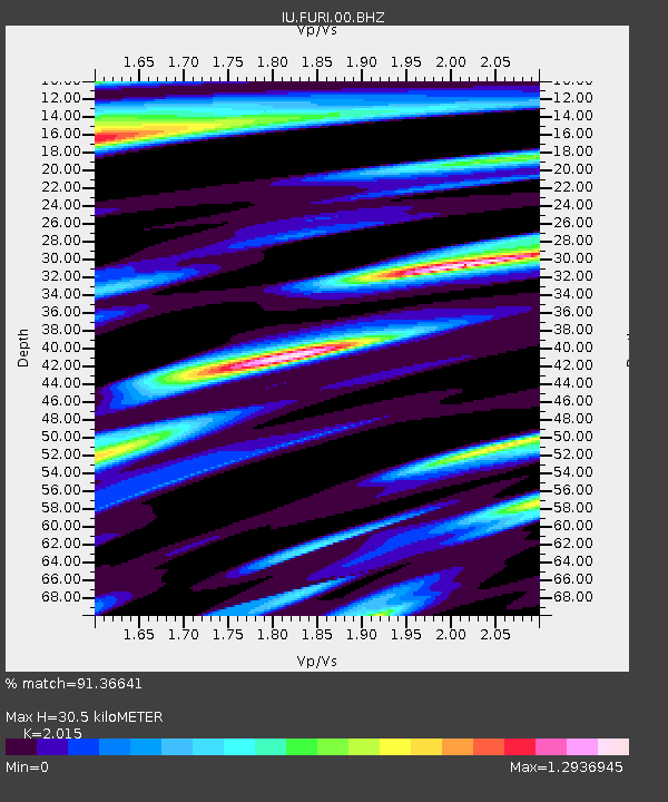
| Estimated Moho Depth: |
30.5 km |
| Estimated Crust Vp/Vs: |
2.02 |
| Assumed Crust Vp: |
6.464 km/s |
| Estimated Crust Vs: |
3.208 km/s |
| Estimated Crust Poisson's Ratio: |
0.34 |
|
| Radial Match: |
91.36641 % |
| Radial Bump: |
400 |
| Transverse Match: |
85.10062 % |
| Transverse Bump: |
400 |
| SOD ConfigId: |
2459 |
| Insert Time: |
2010-03-03 16:23:54.418 +0000 |
| GWidth: |
2.5 |
| Max Bumps: |
400 |
| Tol: |
0.001 |
|
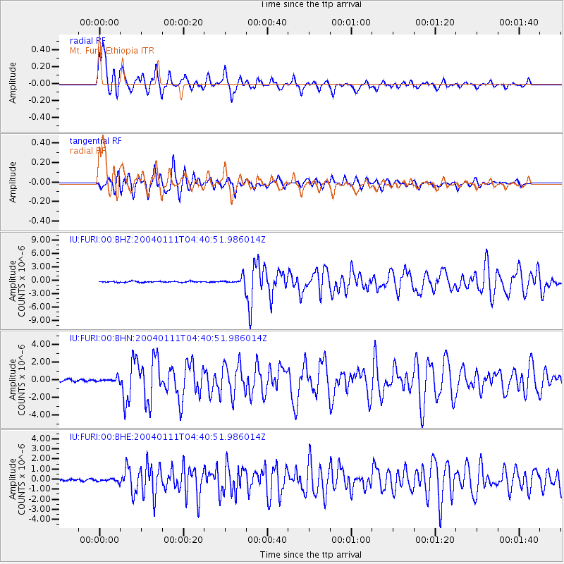
Signal To Noise
| Channel | StoN | STA | LTA |
| IU:FURI:00:BHN:20040111T04:40:51.986014Z | 2.3173883 | 2.3724861E-7 | 1.02377584E-7 |
| IU:FURI:00:BHE:20040111T04:40:51.986014Z | 1.8249317 | 1.568724E-7 | 8.596069E-8 |
| IU:FURI:00:BHZ:20040111T04:40:51.986014Z | 8.3895035 | 8.624492E-7 | 1.0280099E-7 |
| Arrivals |
| Ps | 5.1 SECOND |
| PpPs | 13 SECOND |
| PsPs/PpSs | 19 SECOND |


