You are here: Home > Network List > IU - Global Seismograph Network (GSN - IRIS/USGS) Stations List
> Station FURI Mt. Furi, Ethiopia > Earthquake Result Viewer
FURI Mt. Furi, Ethiopia - Earthquake Result Viewer
| Earthquake location: |
Savu Sea |
| Earthquake latitude/longitude: |
-9.4/122.8 |
| Earthquake time(UTC): |
2004/04/23 (114) 01:50:30 GMT |
| Earthquake Depth: |
66 km |
| Earthquake Magnitude: |
6.5 MB, 6.7 MW, 6.7 MW |
| Earthquake Catalog/Contributor: |
WHDF/NEIC |
|
| Network: |
IU Global Seismograph Network (GSN - IRIS/USGS) |
| Station: |
FURI Mt. Furi, Ethiopia |
| Lat/Lon: |
8.90 N/38.68 E |
| Elevation: |
2570 m |
|
| Distance: |
85.7 deg |
| Az: |
279.69 deg |
| Baz: |
100.114 deg |
| Ray Param: |
0.04442967 |
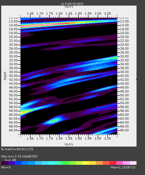
| Estimated Moho Depth: |
13.75 km |
| Estimated Crust Vp/Vs: |
1.69 |
| Assumed Crust Vp: |
6.464 km/s |
| Estimated Crust Vs: |
3.825 km/s |
| Estimated Crust Poisson's Ratio: |
0.23 |
|
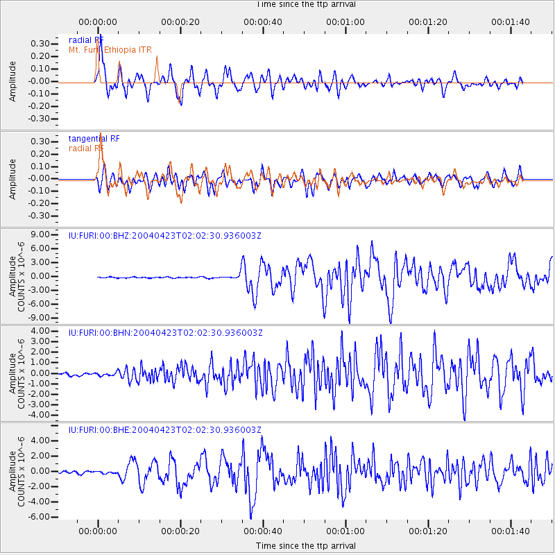
| Radial Match: |
88.911125 % |
| Radial Bump: |
400 |
| Transverse Match: |
84.02636 % |
| Transverse Bump: |
400 |
| SOD ConfigId: |
2459 |
| Insert Time: |
2010-03-03 16:23:59.398 +0000 |
| GWidth: |
2.5 |
| Max Bumps: |
400 |
| Tol: |
0.001 |
|
Signal To Noise
| Channel | StoN | STA | LTA |
| IU:FURI:00:BHN:20040423T02:02:30.936003Z | 1.4199638 | 1.6169653E-7 | 1.1387369E-7 |
| IU:FURI:00:BHE:20040423T02:02:30.936003Z | 1.1207576 | 1.2197302E-7 | 1.0883087E-7 |
| IU:FURI:00:BHZ:20040423T02:02:30.936003Z | 7.0164585 | 6.646321E-7 | 9.472473E-8 |
| Arrivals |
| Ps | 1.5 SECOND |
| PpPs | 5.6 SECOND |
| PsPs/PpSs | 7.1 SECOND |


