You are here: Home > Network List > IU - Global Seismograph Network (GSN - IRIS/USGS) Stations List
> Station FURI Mt. Furi, Ethiopia > Earthquake Result Viewer
FURI Mt. Furi, Ethiopia - Earthquake Result Viewer
| Earthquake location: |
Sichuan, China |
| Earthquake latitude/longitude: |
32.2/105.0 |
| Earthquake time(UTC): |
2008/05/17 (138) 17:08:25 GMT |
| Earthquake Depth: |
9.0 km |
| Earthquake Magnitude: |
5.8 MB, 5.6 MS, 5.7 MW, 5.7 MW |
| Earthquake Catalog/Contributor: |
WHDF/NEIC |
|
| Network: |
IU Global Seismograph Network (GSN - IRIS/USGS) |
| Station: |
FURI Mt. Furi, Ethiopia |
| Lat/Lon: |
8.90 N/38.68 E |
| Elevation: |
2570 m |
|
| Distance: |
65.3 deg |
| Az: |
264.905 deg |
| Baz: |
58.674 deg |
| Ray Param: |
0.058374565 |
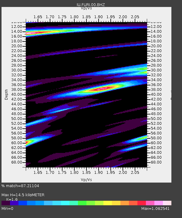
| Estimated Moho Depth: |
14.5 km |
| Estimated Crust Vp/Vs: |
1.60 |
| Assumed Crust Vp: |
6.464 km/s |
| Estimated Crust Vs: |
4.04 km/s |
| Estimated Crust Poisson's Ratio: |
0.18 |
|
| Radial Match: |
87.21104 % |
| Radial Bump: |
400 |
| Transverse Match: |
77.55481 % |
| Transverse Bump: |
400 |
| SOD ConfigId: |
2504 |
| Insert Time: |
2010-03-03 16:24:05.090 +0000 |
| GWidth: |
2.5 |
| Max Bumps: |
400 |
| Tol: |
0.001 |
|
Signal To Noise
| Channel | StoN | STA | LTA |
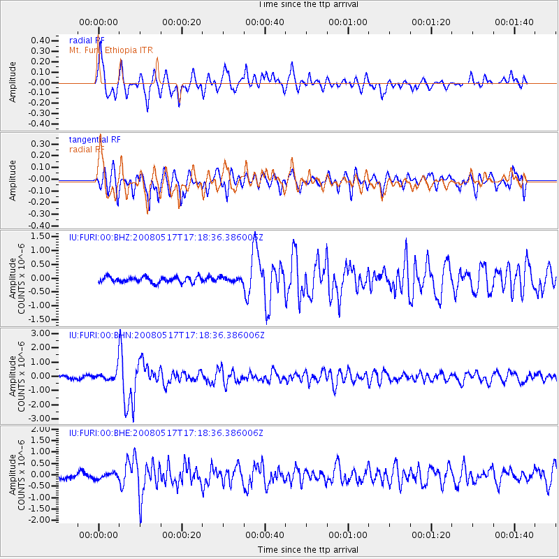
| IU:FURI:00:BHN:20080517T17:18:36.386006Z | 4.0337963 | 4.4004344E-7 | 1.0908916E-7 |
| IU:FURI:00:BHE:20080517T17:18:36.386006Z | 0.9063746 | 1.2352346E-7 | 1.3628302E-7 |
| IU:FURI:00:BHZ:20080517T17:18:36.386006Z | 0.7273696 | 7.631329E-8 | 1.0491679E-7 |
| Arrivals |
| Ps | 1.4 SECOND |
| PpPs | 5.6 SECOND |
| PsPs/PpSs | 7.0 SECOND |


