FURI Mt. Furi, Ethiopia - Earthquake Result Viewer
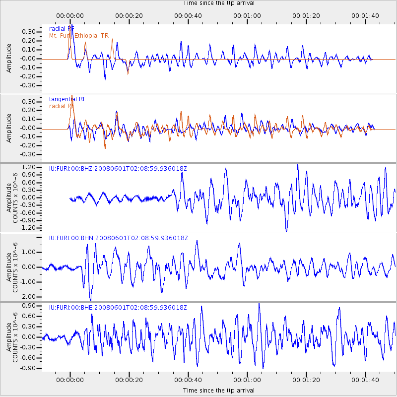
Earthquake location: Philippine Islands Region
Earthquake latitude/longitude: 20.1/121.4
Earthquake time(UTC): 2008/06/01 (153) 01:57:24 GMT
Earthquake Depth: 35 km
Earthquake Magnitude: 6.0 MB, 6.2 MS, 6.3 MW, 6.2 MW
Earthquake Catalog/Contributor: WHDF/NEIC
Network: IU Global Seismograph Network (GSN - IRIS/USGS)
Station: FURI Mt. Furi, Ethiopia
Lat/Lon: 8.90 N/38.68 E
Elevation: 2570 m
Distance: 80.2 deg
Az: 275.903 deg
Baz: 71.071 deg
Ray Param: 0.048409197
Estimated Moho Depth: 14.0 km
Estimated Crust Vp/Vs: 1.60
Assumed Crust Vp: 6.464 km/s
Estimated Crust Vs: 4.04 km/s
Estimated Crust Poisson's Ratio: 0.18
Radial Match: 84.19078 %
Radial Bump: 400
Transverse Match: 76.65802 %
Transverse Bump: 400
SOD ConfigId: 2504
Insert Time: 2010-03-03 16:24:06.196 +0000
GWidth: 2.5
Max Bumps: 400
Tol: 0.001

Signal To Noise

ChannelStoNSTALTA
IU:FURI:00:BHN:20080601T02:08:59.936018Z5.03879554.204144E-78.3435495E-8
IU:FURI:00:BHE:20080601T02:08:59.936018Z1.78200771.4937504E-78.382402E-8
IU:FURI:00:BHZ:20080601T02:08:59.936018Z1.01123641.0144388E-71.00316676E-7
Arrivals
Ps1.3 SECOND
PpPs5.5 SECOND
PsPs/PpSs6.8 SECOND