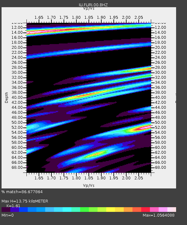
FURI Mt. Furi, Ethiopia - Earthquake Result Viewer

Earthquake location: Off East Coast Of Honshu, Japan
Earthquake latitude/longitude: 37.6/142.2
Earthquake time(UTC): 2008/07/19 (201) 02:39:28 GMT
Earthquake Depth: 22 km
Earthquake Magnitude: 6.2 MB, 7.0 MS, 7.0 MW, 6.9 MW
Earthquake Catalog/Contributor: WHDF/NEIC
Network: IU Global Seismograph Network (GSN - IRIS/USGS)
Station: FURI Mt. Furi, Ethiopia
Lat/Lon: 8.90 N/38.68 E
Elevation: 2570 m
Distance: 95.2 deg
Az: 285.279 deg
Baz: 50.886 deg
Ray Param: 0.0408395
Estimated Moho Depth: 13.75 km
Estimated Crust Vp/Vs: 1.61
Assumed Crust Vp: 6.464 km/s
Estimated Crust Vs: 4.015 km/s
Estimated Crust Poisson's Ratio: 0.19
Radial Match: 86.677864 %
Radial Bump: 400
Transverse Match: 79.82423 %
Transverse Bump: 400
SOD ConfigId: 2504
Insert Time: 2010-03-03 16:24:12.186 +0000
GWidth: 2.5
Max Bumps: 400
Tol: 0.001

Signal To Noise

ChannelStoNSTALTA
IU:FURI:00:BHN:20080719T02:52:18.785022Z7.8482869.3730705E-71.1942825E-7
IU:FURI:00:BHE:20080719T02:52:18.785022Z0.45997211.1333555E-72.4639655E-7
IU:FURI:00:BHZ:20080719T02:52:18.785022Z1.27906232.478803E-71.9379848E-7
Arrivals
Ps1.3 SECOND
PpPs5.4 SECOND
PsPs/PpSs6.8 SECOND