You are here: Home > Network List > TA - USArray Transportable Network (new EarthScope stations) Stations List
> Station MSTX Muleshoe, TX, USA > Earthquake Result Viewer
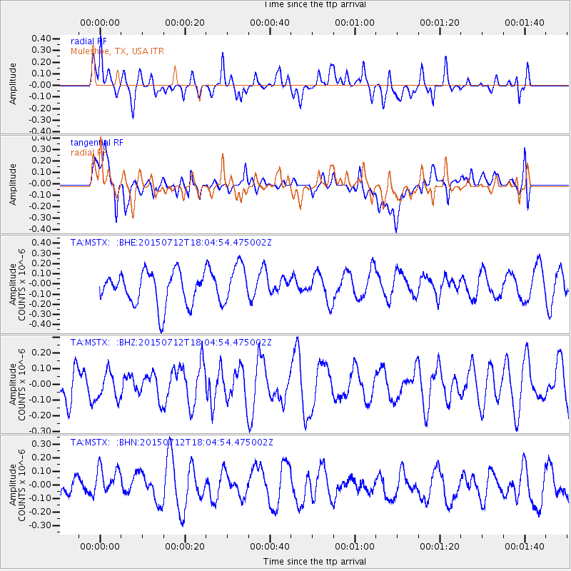
MSTX Muleshoe, TX, USA - Earthquake Result Viewer
*The percent match for this event was below the threshold and hence no stack was calculated.
| Earthquake location: |
Kyushu, Japan |
| Earthquake latitude/longitude: |
33.0/131.8 |
| Earthquake time(UTC): |
2015/07/12 (193) 17:52:05 GMT |
| Earthquake Depth: |
47 km |
| Earthquake Magnitude: |
5.5 MB, 5.5 MWC |
| Earthquake Catalog/Contributor: |
NEIC PDE/NEIC COMCAT |
|
| Network: |
TA USArray Transportable Network (new EarthScope stations) |
| Station: |
MSTX Muleshoe, TX, USA |
| Lat/Lon: |
33.97 N/102.77 W |
| Elevation: |
1167 m |
|
| Distance: |
95.9 deg |
| Az: |
42.879 deg |
| Baz: |
316.545 deg |
| Ray Param: |
$rayparam |
*The percent match for this event was below the threshold and hence was not used in the summary stack. |
|
| Radial Match: |
43.83922 % |
| Radial Bump: |
400 |
| Transverse Match: |
47.98651 % |
| Transverse Bump: |
400 |
| SOD ConfigId: |
7422571 |
| Insert Time: |
2019-04-19 19:07:51.739 +0000 |
| GWidth: |
2.5 |
| Max Bumps: |
400 |
| Tol: |
0.001 |
|
Signal To Noise
| Channel | StoN | STA | LTA |
| TA:MSTX: :BHZ:20150712T18:04:54.475002Z | 0.83957905 | 8.5090015E-8 | 1.0134842E-7 |
| TA:MSTX: :BHN:20150712T18:04:54.475002Z | 1.1971613 | 1.2536114E-7 | 1.0471532E-7 |
| TA:MSTX: :BHE:20150712T18:04:54.475002Z | 1.0954564 | 1.834918E-7 | 1.6750262E-7 |
| Arrivals |
| Ps | |
| PpPs | |
| PsPs/PpSs | |


