You are here: Home > Network List > IU - Global Seismograph Network (GSN - IRIS/USGS) Stations List
> Station FURI Mt. Furi, Ethiopia > Earthquake Result Viewer
FURI Mt. Furi, Ethiopia - Earthquake Result Viewer
| Earthquake location: |
Mid-Indian Ridge |
| Earthquake latitude/longitude: |
-13.1/66.1 |
| Earthquake time(UTC): |
2009/01/13 (013) 01:04:42 GMT |
| Earthquake Depth: |
10 km |
| Earthquake Magnitude: |
5.5 MB, 5.6 MS, 6.0 MW, 6.0 MW |
| Earthquake Catalog/Contributor: |
WHDF/NEIC |
|
| Network: |
IU Global Seismograph Network (GSN - IRIS/USGS) |
| Station: |
FURI Mt. Furi, Ethiopia |
| Lat/Lon: |
8.90 N/38.68 E |
| Elevation: |
2570 m |
|
| Distance: |
34.9 deg |
| Az: |
307.421 deg |
| Baz: |
128.47 deg |
| Ray Param: |
0.077488445 |
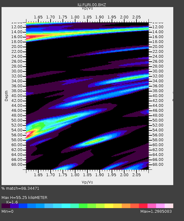
| Estimated Moho Depth: |
55.25 km |
| Estimated Crust Vp/Vs: |
1.60 |
| Assumed Crust Vp: |
6.464 km/s |
| Estimated Crust Vs: |
4.04 km/s |
| Estimated Crust Poisson's Ratio: |
0.18 |
|
| Radial Match: |
86.34471 % |
| Radial Bump: |
364 |
| Transverse Match: |
65.29937 % |
| Transverse Bump: |
400 |
| SOD ConfigId: |
2834 |
| Insert Time: |
2010-03-03 16:24:16.313 +0000 |
| GWidth: |
2.5 |
| Max Bumps: |
400 |
| Tol: |
0.001 |
|
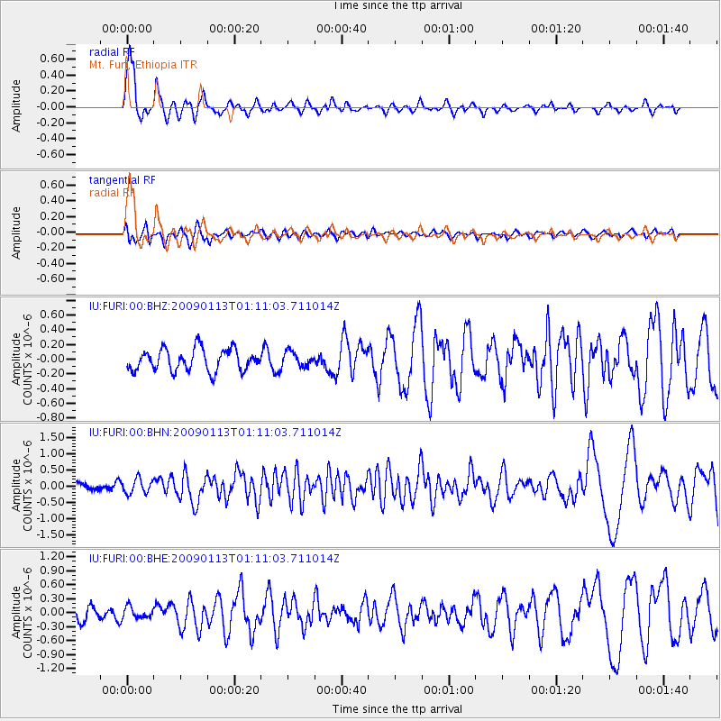
Signal To Noise
| Channel | StoN | STA | LTA |
| IU:FURI:00:BHN:20090113T01:11:03.711014Z | 2.4172766 | 2.2683344E-7 | 9.383843E-8 |
| IU:FURI:00:BHE:20090113T01:11:03.711014Z | 0.851467 | 1.18722994E-7 | 1.3943347E-7 |
| IU:FURI:00:BHZ:20090113T01:11:03.711014Z | 0.6552276 | 9.634189E-8 | 1.4703576E-7 |
| Arrivals |
| Ps | 5.6 SECOND |
| PpPs | 20 SECOND |
| PsPs/PpSs | 26 SECOND |


