You are here: Home > Network List > IU - Global Seismograph Network (GSN - IRIS/USGS) Stations List
> Station FURI Mt. Furi, Ethiopia > Earthquake Result Viewer
FURI Mt. Furi, Ethiopia - Earthquake Result Viewer
| Earthquake location: |
Ionian Sea |
| Earthquake latitude/longitude: |
37.6/20.7 |
| Earthquake time(UTC): |
1997/11/18 (322) 13:07:41 GMT |
| Earthquake Depth: |
33 km |
| Earthquake Magnitude: |
5.9 MB, 6.4 MS, 6.7 UNKNOWN, 6.1 ML |
| Earthquake Catalog/Contributor: |
WHDF/NEIC |
|
| Network: |
IU Global Seismograph Network (GSN - IRIS/USGS) |
| Station: |
FURI Mt. Furi, Ethiopia |
| Lat/Lon: |
8.90 N/38.68 E |
| Elevation: |
2570 m |
|
| Distance: |
32.9 deg |
| Az: |
145.715 deg |
| Baz: |
333.065 deg |
| Ray Param: |
0.07841563 |
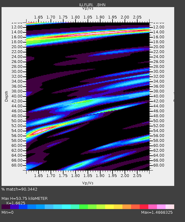
| Estimated Moho Depth: |
53.75 km |
| Estimated Crust Vp/Vs: |
1.66 |
| Assumed Crust Vp: |
6.464 km/s |
| Estimated Crust Vs: |
3.888 km/s |
| Estimated Crust Poisson's Ratio: |
0.22 |
|
| Radial Match: |
90.3442 % |
| Radial Bump: |
393 |
| Transverse Match: |
86.34231 % |
| Transverse Bump: |
400 |
| SOD ConfigId: |
6273 |
| Insert Time: |
2010-03-03 16:24:24.080 +0000 |
| GWidth: |
2.5 |
| Max Bumps: |
400 |
| Tol: |
0.001 |
|

Signal To Noise
| Channel | StoN | STA | LTA |
| IU:FURI: :BHN:19971118T13:13:42.17699Z | 5.364131 | 5.437512E-7 | 1.01367995E-7 |
| IU:FURI: :BHE:19971118T13:13:42.17699Z | 2.2976596 | 2.3841116E-7 | 1.0376261E-7 |
| IU:FURI: :BHZ:19971118T13:13:42.17699Z | 12.647948 | 1.3935141E-6 | 1.1017709E-7 |
| Arrivals |
| Ps | 6.0 SECOND |
| PpPs | 20 SECOND |
| PsPs/PpSs | 26 SECOND |


