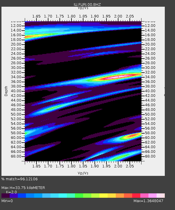
FURI Mt. Furi, Ethiopia - Earthquake Result Viewer

Earthquake location: Northern Sumatra, Indonesia
Earthquake latitude/longitude: 1.8/97.1
Earthquake time(UTC): 2005/07/05 (186) 01:52:02 GMT
Earthquake Depth: 21 km
Earthquake Magnitude: 6.2 MB, 6.8 MS, 6.7 MW, 6.6 MW
Earthquake Catalog/Contributor: WHDF/NEIC
Network: IU Global Seismograph Network (GSN - IRIS/USGS)
Station: FURI Mt. Furi, Ethiopia
Lat/Lon: 8.90 N/38.68 E
Elevation: 2570 m
Distance: 58.5 deg
Az: 279.26 deg
Baz: 93.314 deg
Ray Param: 0.062770545
Estimated Moho Depth: 33.75 km
Estimated Crust Vp/Vs: 2.00
Assumed Crust Vp: 6.464 km/s
Estimated Crust Vs: 3.232 km/s
Estimated Crust Poisson's Ratio: 0.33
Radial Match: 96.12106 %
Radial Bump: 355
Transverse Match: 84.84578 %
Transverse Bump: 400
SOD ConfigId: 2669
Insert Time: 2010-03-03 16:24:33.599 +0000
GWidth: 2.5
Max Bumps: 400
Tol: 0.001

Signal To Noise

ChannelStoNSTALTA
IU:FURI:00:BHN:20050705T02:01:26.58501Z0.434325257.5872755E-81.7469111E-7
IU:FURI:00:BHE:20050705T02:01:26.58501Z0.504061948.9176105E-81.7691498E-7
IU:FURI:00:BHZ:20050705T02:01:26.58501Z1.27433561.3423788E-71.053395E-7
Arrivals
Ps5.5 SECOND
PpPs15 SECOND
PsPs/PpSs20 SECOND