FURI Mt. Furi, Ethiopia - Earthquake Result Viewer
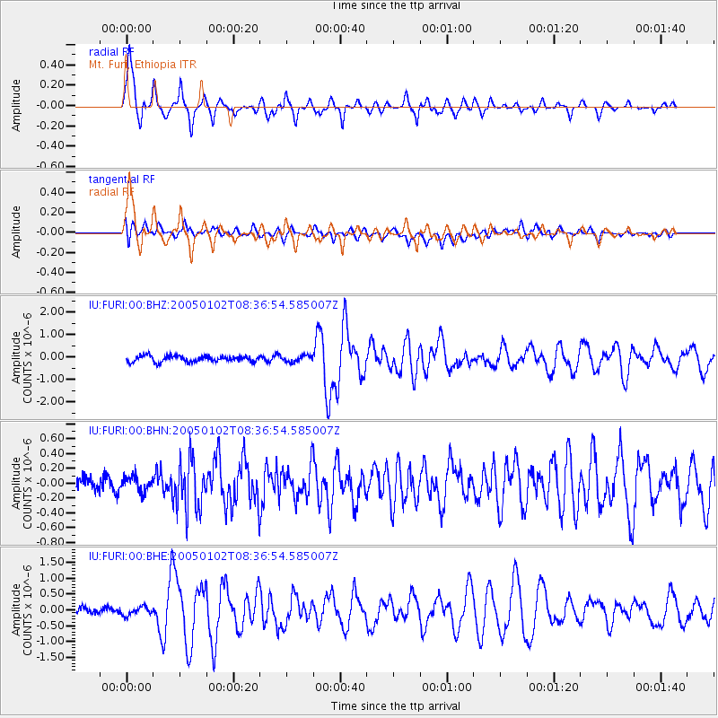
Earthquake location: Off W Coast Of Northern Sumatra
Earthquake latitude/longitude: 3.2/95.5
Earthquake time(UTC): 2005/01/02 (002) 08:27:41 GMT
Earthquake Depth: 8.4 km
Earthquake Magnitude: 5.6 MB, 5.9 MS, 5.9 MW, 5.8 MW
Earthquake Catalog/Contributor: WHDF/NEIC
Network: IU Global Seismograph Network (GSN - IRIS/USGS)
Station: FURI Mt. Furi, Ethiopia
Lat/Lon: 8.90 N/38.68 E
Elevation: 2570 m
Distance: 56.7 deg
Az: 278.461 deg
Baz: 91.955 deg
Ray Param: 0.06397763
Estimated Moho Depth: 69.75 km
Estimated Crust Vp/Vs: 1.92
Assumed Crust Vp: 6.464 km/s
Estimated Crust Vs: 3.362 km/s
Estimated Crust Poisson's Ratio: 0.31
Radial Match: 91.01886 %
Radial Bump: 385
Transverse Match: 72.78129 %
Transverse Bump: 400
SOD ConfigId: 5233
Insert Time: 2010-03-03 16:24:38.641 +0000
GWidth: 2.5
Max Bumps: 400
Tol: 0.001

Signal To Noise

ChannelStoNSTALTA
IU:FURI:00:BHN:20050102T08:36:54.585007Z1.01131871.2396727E-71.2257982E-7
IU:FURI:00:BHE:20050102T08:36:54.585007Z1.18330651.3472696E-71.1385635E-7
IU:FURI:00:BHZ:20050102T08:36:54.585007Z1.04448071.4128086E-71.3526422E-7
Arrivals
Ps10 SECOND
PpPs30 SECOND
PsPs/PpSs41 SECOND