You are here: Home > Network List > IU - Global Seismograph Network (GSN - IRIS/USGS) Stations List
> Station FURI Mt. Furi, Ethiopia > Earthquake Result Viewer
FURI Mt. Furi, Ethiopia - Earthquake Result Viewer

| Earthquake location: |
Ionian Sea |
| Earthquake latitude/longitude: |
37.5/20.2 |
| Earthquake time(UTC): |
2005/01/31 (031) 01:05:33 GMT |
| Earthquake Depth: |
32 km |
| Earthquake Magnitude: |
5.1 MB, 5.4 MS, 5.8 MW, 5.7 MW |
| Earthquake Catalog/Contributor: |
WHDF/NEIC |
|
| Network: |
IU Global Seismograph Network (GSN - IRIS/USGS) |
| Station: |
FURI Mt. Furi, Ethiopia |
| Lat/Lon: |
8.90 N/38.68 E |
| Elevation: |
2570 m |
|
| Distance: |
33.1 deg |
| Az: |
144.876 deg |
| Baz: |
332.427 deg |
| Ray Param: |
0.078326665 |
| Estimated Moho Depth: |
10.0 km |
| Estimated Crust Vp/Vs: |
1.60 |
| Assumed Crust Vp: |
6.464 km/s |
| Estimated Crust Vs: |
4.04 km/s |
| Estimated Crust Poisson's Ratio: |
0.18 |
|
| Radial Match: |
83.34779 % |
| Radial Bump: |
400 |
| Transverse Match: |
78.42341 % |
| Transverse Bump: |
400 |
| SOD ConfigId: |
5233 |
| Insert Time: |
2010-03-03 16:24:39.825 +0000 |
| GWidth: |
2.5 |
| Max Bumps: |
400 |
| Tol: |
0.001 |
|
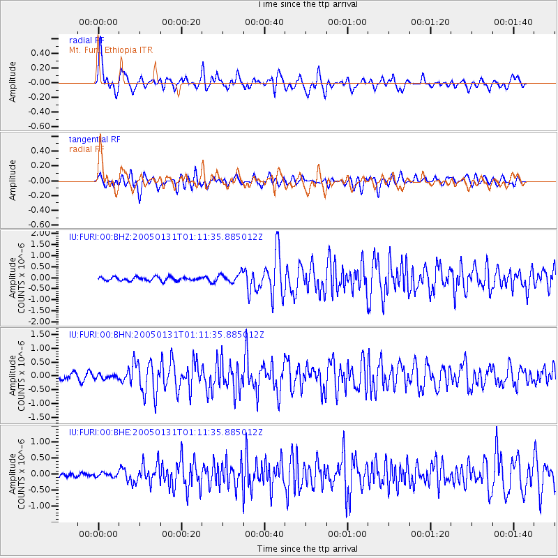
Signal To Noise
| Channel | StoN | STA | LTA |
| IU:FURI:00:BHN:20050131T01:11:35.885012Z | 0.46285468 | 7.4360344E-8 | 1.6065593E-7 |
| IU:FURI:00:BHE:20050131T01:11:35.885012Z | 0.662613 | 6.222359E-8 | 9.3906394E-8 |
| IU:FURI:00:BHZ:20050131T01:11:35.885012Z | 2.5018995 | 2.129735E-7 | 8.5124725E-8 |
| Arrivals |
| Ps | 1.0 SECOND |
| PpPs | 3.7 SECOND |
| PsPs/PpSs | 4.7 SECOND |


