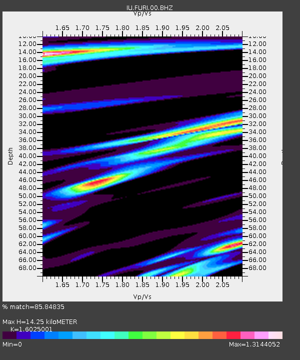
FURI Mt. Furi, Ethiopia - Earthquake Result Viewer

Earthquake location: Southern Sumatra, Indonesia
Earthquake latitude/longitude: -1.6/99.7
Earthquake time(UTC): 2005/04/10 (100) 17:24:39 GMT
Earthquake Depth: 30 km
Earthquake Magnitude: 5.9 MB, 6.2 MS, 6.4 MW, 6.1 MW
Earthquake Catalog/Contributor: WHDF/NEIC
Network: IU Global Seismograph Network (GSN - IRIS/USGS)
Station: FURI Mt. Furi, Ethiopia
Lat/Lon: 8.90 N/38.68 E
Elevation: 2570 m
Distance: 61.7 deg
Az: 280.917 deg
Baz: 96.627 deg
Ray Param: 0.060660392
Estimated Moho Depth: 14.25 km
Estimated Crust Vp/Vs: 1.60
Assumed Crust Vp: 6.464 km/s
Estimated Crust Vs: 4.033 km/s
Estimated Crust Poisson's Ratio: 0.18
Radial Match: 85.84835 %
Radial Bump: 400
Transverse Match: 71.985725 %
Transverse Bump: 400
SOD ConfigId: 2459
Insert Time: 2010-03-03 16:24:51.819 +0000
GWidth: 2.5
Max Bumps: 400
Tol: 0.001

Signal To Noise

ChannelStoNSTALTA
IU:FURI:00:BHN:20050410T17:34:23.78501Z1.0363461.625497E-71.5684888E-7
IU:FURI:00:BHE:20050410T17:34:23.78501Z2.15641142.1429733E-79.9376834E-8
IU:FURI:00:BHZ:20050410T17:34:23.78501Z4.4128936.726279E-71.5242334E-7
Arrivals
Ps1.4 SECOND
PpPs5.5 SECOND
PsPs/PpSs6.9 SECOND