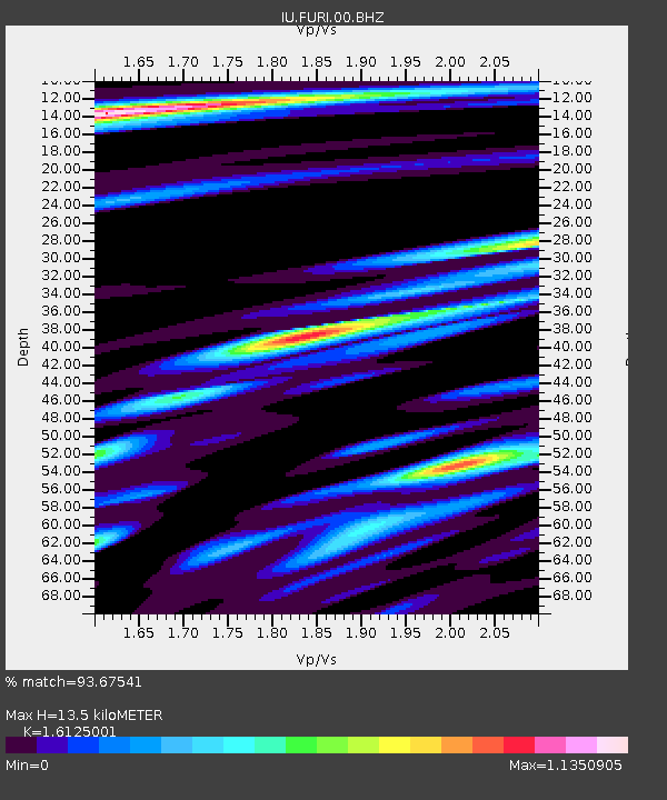
FURI Mt. Furi, Ethiopia - Earthquake Result Viewer

Earthquake location: Near East Coast Of Honshu, Japan
Earthquake latitude/longitude: 38.3/142.0
Earthquake time(UTC): 2005/08/16 (228) 02:46:28 GMT
Earthquake Depth: 36 km
Earthquake Magnitude: 6.5 MB, 6.8 MS, 7.2 MW, 7.1 MW
Earthquake Catalog/Contributor: WHDF/NEIC
Network: IU Global Seismograph Network (GSN - IRIS/USGS)
Station: FURI Mt. Furi, Ethiopia
Lat/Lon: 8.90 N/38.68 E
Elevation: 2570 m
Distance: 94.9 deg
Az: 285.23 deg
Baz: 50.222 deg
Ray Param: 0.04091597
Estimated Moho Depth: 13.5 km
Estimated Crust Vp/Vs: 1.61
Assumed Crust Vp: 6.464 km/s
Estimated Crust Vs: 4.008 km/s
Estimated Crust Poisson's Ratio: 0.19
Radial Match: 93.67541 %
Radial Bump: 400
Transverse Match: 91.47266 %
Transverse Bump: 400
SOD ConfigId: 2475
Insert Time: 2010-03-03 16:24:53.455 +0000
GWidth: 2.5
Max Bumps: 400
Tol: 0.001

Signal To Noise

ChannelStoNSTALTA
IU:FURI:00:BHN:20050816T02:59:15.235022Z1.67717622.6730453E-71.5937772E-7
IU:FURI:00:BHE:20050816T02:59:15.235022Z1.77200982.145985E-71.2110458E-7
IU:FURI:00:BHZ:20050816T02:59:15.235022Z4.3416487.9874616E-71.8397304E-7
Arrivals
Ps1.3 SECOND
PpPs5.3 SECOND
PsPs/PpSs6.6 SECOND