You are here: Home > Network List > IU - Global Seismograph Network (GSN - IRIS/USGS) Stations List
> Station FURI Mt. Furi, Ethiopia > Earthquake Result Viewer
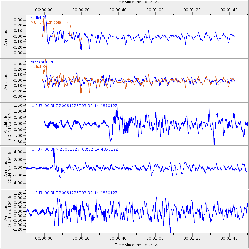
FURI Mt. Furi, Ethiopia - Earthquake Result Viewer

| Earthquake location: |
Mindanao, Philippines |
| Earthquake latitude/longitude: |
5.8/125.4 |
| Earthquake time(UTC): |
2008/12/25 (360) 03:20:29 GMT |
| Earthquake Depth: |
211 km |
| Earthquake Magnitude: |
6.1 MB, 6.3 MW, 6.3 MW |
| Earthquake Catalog/Contributor: |
WHDF/NEIC |
|
| Network: |
IU Global Seismograph Network (GSN - IRIS/USGS) |
| Station: |
FURI Mt. Furi, Ethiopia |
| Lat/Lon: |
8.90 N/38.68 E |
| Elevation: |
2570 m |
|
| Distance: |
85.9 deg |
| Az: |
278.485 deg |
| Baz: |
84.845 deg |
| Ray Param: |
0.043960266 |
| Estimated Moho Depth: |
13.75 km |
| Estimated Crust Vp/Vs: |
1.60 |
| Assumed Crust Vp: |
6.464 km/s |
| Estimated Crust Vs: |
4.04 km/s |
| Estimated Crust Poisson's Ratio: |
0.18 |
|
| Radial Match: |
80.72959 % |
| Radial Bump: |
400 |
| Transverse Match: |
69.80679 % |
| Transverse Bump: |
400 |
| SOD ConfigId: |
2658 |
| Insert Time: |
2010-03-03 16:25:14.233 +0000 |
| GWidth: |
2.5 |
| Max Bumps: |
400 |
| Tol: |
0.001 |
|
Signal To Noise
| Channel | StoN | STA | LTA |
| IU:FURI:00:BHN:20081225T03:32:14.485012Z | 2.7186253 | 3.6008288E-7 | 1.3245035E-7 |
| IU:FURI:00:BHE:20081225T03:32:14.485012Z | 0.9697432 | 1.4020891E-7 | 1.4458355E-7 |
| IU:FURI:00:BHZ:20081225T03:32:14.485012Z | 0.8220287 | 1.4622529E-7 | 1.7788344E-7 |
| Arrivals |
| Ps | 1.3 SECOND |
| PpPs | 5.4 SECOND |
| PsPs/PpSs | 6.7 SECOND |


