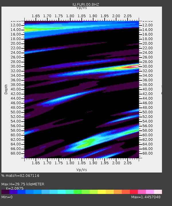
FURI Mt. Furi, Ethiopia - Earthquake Result Viewer

Earthquake location: Prince Edward Islands Region
Earthquake latitude/longitude: -47.8/32.6
Earthquake time(UTC): 2006/06/09 (160) 23:17:27 GMT
Earthquake Depth: 22 km
Earthquake Magnitude: 5.6 MB, 5.8 MS, 5.9 MW, 5.7 MW
Earthquake Catalog/Contributor: WHDF/NEIC
Network: IU Global Seismograph Network (GSN - IRIS/USGS)
Station: FURI Mt. Furi, Ethiopia
Lat/Lon: 8.90 N/38.68 E
Elevation: 2570 m
Distance: 56.7 deg
Az: 7.183 deg
Baz: 184.899 deg
Ray Param: 0.06397182
Estimated Moho Depth: 29.75 km
Estimated Crust Vp/Vs: 2.10
Assumed Crust Vp: 6.464 km/s
Estimated Crust Vs: 3.082 km/s
Estimated Crust Poisson's Ratio: 0.35
Radial Match: 82.067116 %
Radial Bump: 400
Transverse Match: 79.17525 %
Transverse Bump: 400
SOD ConfigId: 2669
Insert Time: 2010-03-03 16:25:29.353 +0000
GWidth: 2.5
Max Bumps: 400
Tol: 0.001

Signal To Noise

ChannelStoNSTALTA
IU:FURI:00:BHN:20060609T23:26:38.335017Z3.22564744.131838E-71.280933E-7
IU:FURI:00:BHE:20060609T23:26:38.335017Z1.065231.3156482E-71.2350837E-7
IU:FURI:00:BHZ:20060609T23:26:38.335017Z11.6847811.1628491E-69.951825E-8
Arrivals
Ps5.3 SECOND
PpPs14 SECOND
PsPs/PpSs19 SECOND