You are here: Home > Network List > IU - Global Seismograph Network (GSN - IRIS/USGS) Stations List
> Station FURI Mt. Furi, Ethiopia > Earthquake Result Viewer
FURI Mt. Furi, Ethiopia - Earthquake Result Viewer

| Earthquake location: |
Mozambique |
| Earthquake latitude/longitude: |
-21.3/33.6 |
| Earthquake time(UTC): |
2006/02/22 (053) 22:19:07 GMT |
| Earthquake Depth: |
11 km |
| Earthquake Magnitude: |
6.5 MB, 7.5 MS, 7.0 MW, 7.0 MW |
| Earthquake Catalog/Contributor: |
WHDF/NEIC |
|
| Network: |
IU Global Seismograph Network (GSN - IRIS/USGS) |
| Station: |
FURI Mt. Furi, Ethiopia |
| Lat/Lon: |
8.90 N/38.68 E |
| Elevation: |
2570 m |
|
| Distance: |
30.4 deg |
| Az: |
9.976 deg |
| Baz: |
189.408 deg |
| Ray Param: |
0.079329 |
| Estimated Moho Depth: |
32.0 km |
| Estimated Crust Vp/Vs: |
1.89 |
| Assumed Crust Vp: |
6.464 km/s |
| Estimated Crust Vs: |
3.424 km/s |
| Estimated Crust Poisson's Ratio: |
0.30 |
|
| Radial Match: |
90.905525 % |
| Radial Bump: |
400 |
| Transverse Match: |
68.50145 % |
| Transverse Bump: |
400 |
| SOD ConfigId: |
2422 |
| Insert Time: |
2010-03-03 16:25:40.352 +0000 |
| GWidth: |
2.5 |
| Max Bumps: |
400 |
| Tol: |
0.001 |
|
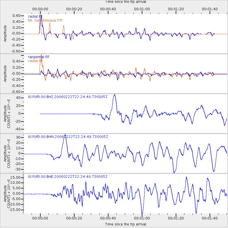
Signal To Noise
| Channel | StoN | STA | LTA |
| IU:FURI:00:BHN:20060222T22:24:49.736005Z | 3.5691354 | 3.9588602E-7 | 1.109193E-7 |
| IU:FURI:00:BHE:20060222T22:24:49.736005Z | 1.6233897 | 1.0135338E-7 | 6.243318E-8 |
| IU:FURI:00:BHZ:20060222T22:24:49.736005Z | 10.546382 | 9.333908E-7 | 8.850341E-8 |
| Arrivals |
| Ps | 4.7 SECOND |
| PpPs | 13 SECOND |
| PsPs/PpSs | 18 SECOND |


