You are here: Home > Network List > TA - USArray Transportable Network (new EarthScope stations) Stations List
> Station O03E Paynes Creek, CA, USA > Earthquake Result Viewer
O03E Paynes Creek, CA, USA - Earthquake Result Viewer
*The percent match for this event was below the threshold and hence no stack was calculated.
| Earthquake location: |
Kuril Islands |
| Earthquake latitude/longitude: |
45.9/151.8 |
| Earthquake time(UTC): |
2015/07/12 (193) 20:23:18 GMT |
| Earthquake Depth: |
100 km |
| Earthquake Magnitude: |
4.4 mb |
| Earthquake Catalog/Contributor: |
ISC/ISC |
|
| Network: |
TA USArray Transportable Network (new EarthScope stations) |
| Station: |
O03E Paynes Creek, CA, USA |
| Lat/Lon: |
40.29 N/121.80 W |
| Elevation: |
967 m |
|
| Distance: |
60.4 deg |
| Az: |
61.433 deg |
| Baz: |
306.739 deg |
| Ray Param: |
$rayparam |
*The percent match for this event was below the threshold and hence was not used in the summary stack. |
|
| Radial Match: |
32.183815 % |
| Radial Bump: |
400 |
| Transverse Match: |
68.322914 % |
| Transverse Bump: |
400 |
| SOD ConfigId: |
7422571 |
| Insert Time: |
2019-04-19 19:16:10.553 +0000 |
| GWidth: |
2.5 |
| Max Bumps: |
400 |
| Tol: |
0.001 |
|
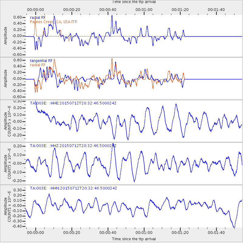
Signal To Noise
| Channel | StoN | STA | LTA |
| TA:O03E: :HHZ:20150712T20:32:46.500024Z | 0.7183625 | 5.3138226E-8 | 7.397133E-8 |
| TA:O03E: :HHN:20150712T20:32:46.500024Z | 1.0782377 | 8.7301814E-8 | 8.096714E-8 |
| TA:O03E: :HHE:20150712T20:32:46.500024Z | 0.46382582 | 4.162964E-8 | 8.9752746E-8 |
| Arrivals |
| Ps | |
| PpPs | |
| PsPs/PpSs | |


