You are here: Home > Network List > TA - USArray Transportable Network (new EarthScope stations) Stations List
> Station X43A Marvell, AR, USA > Earthquake Result Viewer
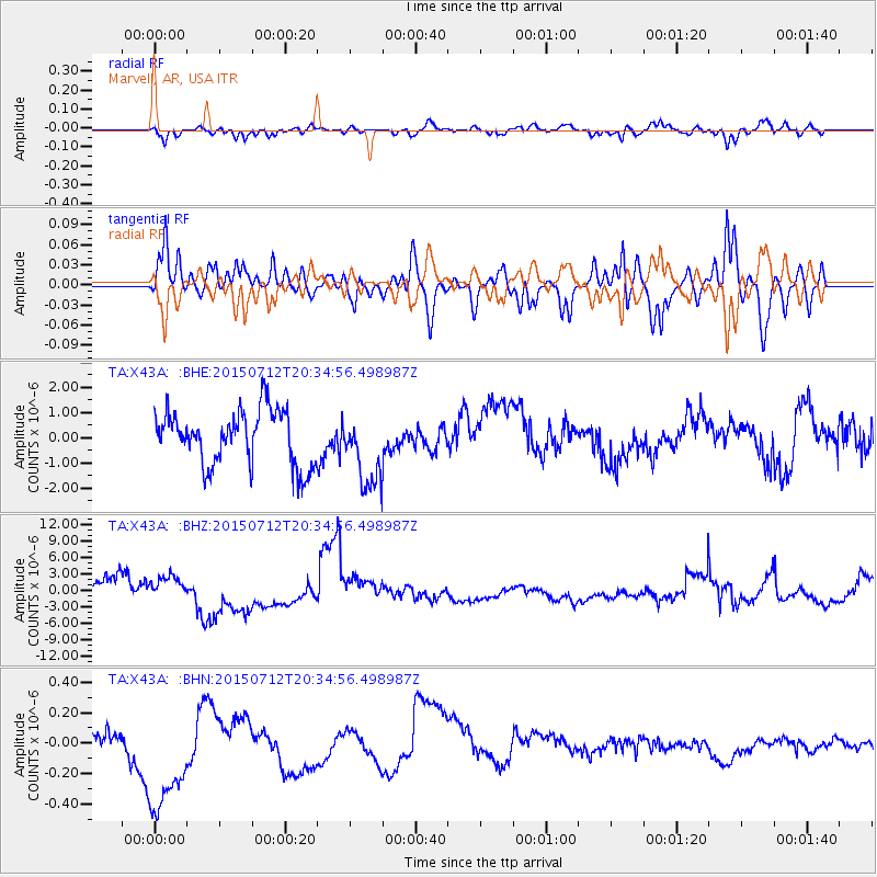
X43A Marvell, AR, USA - Earthquake Result Viewer
*The percent match for this event was below the threshold and hence no stack was calculated.
| Earthquake location: |
Kuril Islands |
| Earthquake latitude/longitude: |
45.9/151.8 |
| Earthquake time(UTC): |
2015/07/12 (193) 20:23:18 GMT |
| Earthquake Depth: |
100 km |
| Earthquake Magnitude: |
4.4 mb |
| Earthquake Catalog/Contributor: |
ISC/ISC |
|
| Network: |
TA USArray Transportable Network (new EarthScope stations) |
| Station: |
X43A Marvell, AR, USA |
| Lat/Lon: |
34.52 N/90.88 W |
| Elevation: |
53 m |
|
| Distance: |
82.0 deg |
| Az: |
47.773 deg |
| Baz: |
321.254 deg |
| Ray Param: |
$rayparam |
*The percent match for this event was below the threshold and hence was not used in the summary stack. |
|
| Radial Match: |
74.55331 % |
| Radial Bump: |
400 |
| Transverse Match: |
68.13309 % |
| Transverse Bump: |
400 |
| SOD ConfigId: |
7422571 |
| Insert Time: |
2019-04-19 19:16:17.280 +0000 |
| GWidth: |
2.5 |
| Max Bumps: |
400 |
| Tol: |
0.001 |
|
Signal To Noise
| Channel | StoN | STA | LTA |
| TA:X43A: :BHZ:20150712T20:34:56.498987Z | 1.2294524 | 2.0363311E-6 | 1.6562911E-6 |
| TA:X43A: :BHN:20150712T20:34:56.498987Z | 3.82807 | 4.803016E-7 | 1.2546835E-7 |
| TA:X43A: :BHE:20150712T20:34:56.498987Z | 1.312513 | 1.4066445E-6 | 1.0717185E-6 |
| Arrivals |
| Ps | |
| PpPs | |
| PsPs/PpSs | |


