You are here: Home > Network List > IU - Global Seismograph Network (GSN - IRIS/USGS) Stations List
> Station FURI Mt. Furi, Ethiopia > Earthquake Result Viewer
FURI Mt. Furi, Ethiopia - Earthquake Result Viewer

| Earthquake location: |
Southern Greece |
| Earthquake latitude/longitude: |
36.3/23.2 |
| Earthquake time(UTC): |
2006/01/08 (008) 11:34:55 GMT |
| Earthquake Depth: |
66 km |
| Earthquake Magnitude: |
6.5 MB, 6.7 MW, 6.7 MW |
| Earthquake Catalog/Contributor: |
WHDF/NEIC |
|
| Network: |
IU Global Seismograph Network (GSN - IRIS/USGS) |
| Station: |
FURI Mt. Furi, Ethiopia |
| Lat/Lon: |
8.90 N/38.68 E |
| Elevation: |
2570 m |
|
| Distance: |
30.7 deg |
| Az: |
148.932 deg |
| Baz: |
335.05 deg |
| Ray Param: |
0.07916563 |
| Estimated Moho Depth: |
45.25 km |
| Estimated Crust Vp/Vs: |
1.75 |
| Assumed Crust Vp: |
6.464 km/s |
| Estimated Crust Vs: |
3.693 km/s |
| Estimated Crust Poisson's Ratio: |
0.26 |
|
| Radial Match: |
89.79813 % |
| Radial Bump: |
400 |
| Transverse Match: |
80.71512 % |
| Transverse Bump: |
400 |
| SOD ConfigId: |
4977 |
| Insert Time: |
2010-03-03 16:25:45.244 +0000 |
| GWidth: |
2.5 |
| Max Bumps: |
400 |
| Tol: |
0.001 |
|
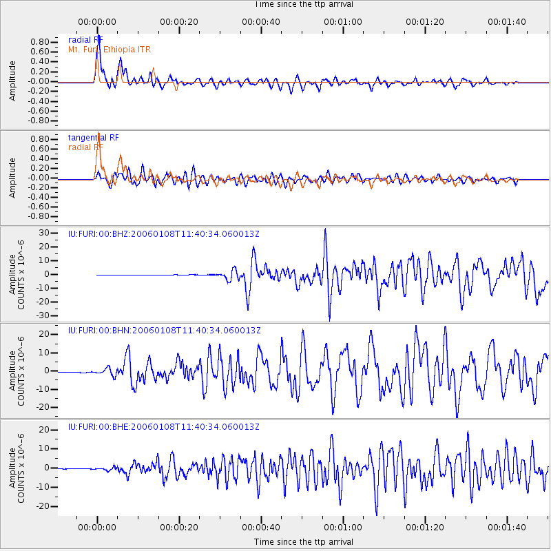
Signal To Noise
| Channel | StoN | STA | LTA |
| IU:FURI:00:BHN:20060108T11:40:34.060013Z | 19.464518 | 1.9512252E-6 | 1.00245224E-7 |
| IU:FURI:00:BHE:20060108T11:40:34.060013Z | 9.330859 | 7.3808343E-7 | 7.910134E-8 |
| IU:FURI:00:BHZ:20060108T11:40:34.060013Z | 25.521832 | 3.482634E-6 | 1.3645706E-7 |
| Arrivals |
| Ps | 5.7 SECOND |
| PpPs | 18 SECOND |
| PsPs/PpSs | 23 SECOND |


