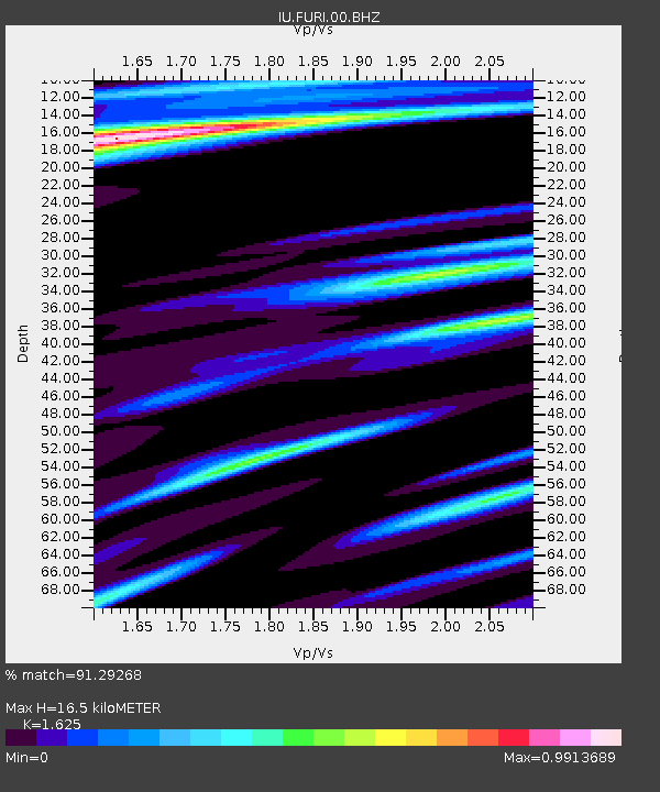
FURI Mt. Furi, Ethiopia - Earthquake Result Viewer
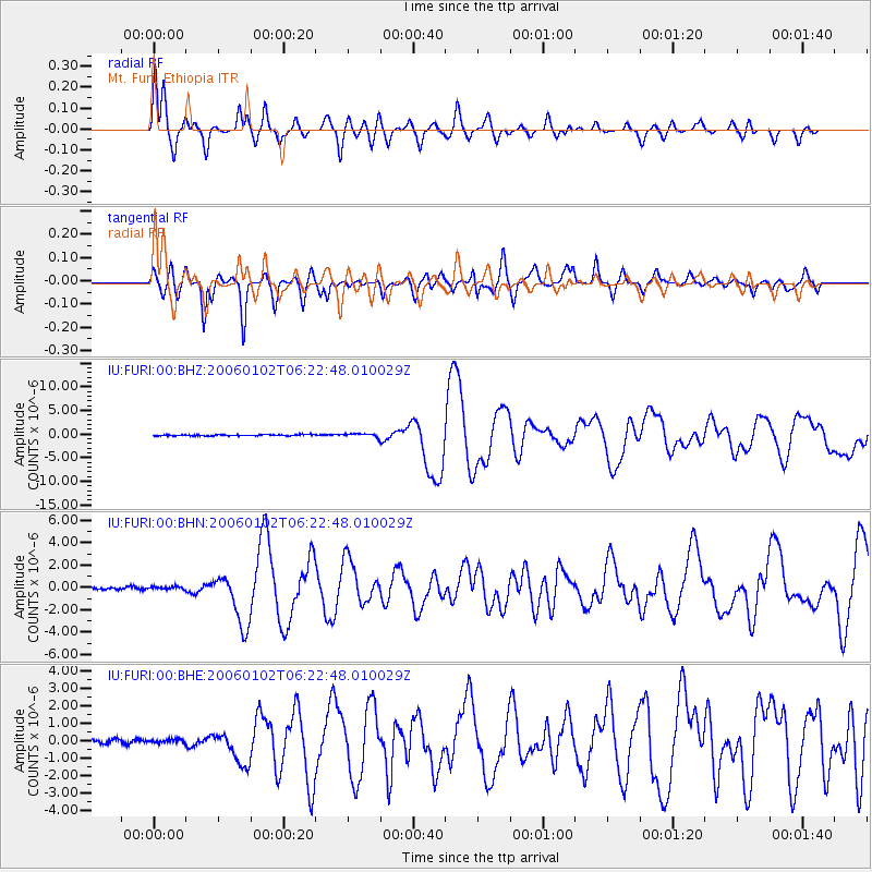
Earthquake location: Southwestern Atlantic Ocean
Earthquake latitude/longitude: -60.9/-21.6
Earthquake time(UTC): 2006/01/02 (002) 06:10:49 GMT
Earthquake Depth: 10 km
Earthquake Magnitude: 6.4 MB, 7.3 MS, 7.4 MW, 7.1 MW
Earthquake Catalog/Contributor: WHDF/NEIC
Network: IU Global Seismograph Network (GSN - IRIS/USGS)
Station: FURI Mt. Furi, Ethiopia
Lat/Lon: 8.90 N/38.68 E
Elevation: 2570 m
Distance: 84.0 deg
Az: 59.625 deg
Baz: 205.236 deg
Ray Param: 0.045821104
Estimated Moho Depth: 16.5 km
Estimated Crust Vp/Vs: 1.62
Assumed Crust Vp: 6.464 km/s
Estimated Crust Vs: 3.978 km/s
Estimated Crust Poisson's Ratio: 0.20
Radial Match: 91.29268 %
Radial Bump: 400
Transverse Match: 85.39948 %
Transverse Bump: 400
SOD ConfigId: 4977
Insert Time: 2010-03-03 16:25:49.254 +0000
GWidth: 2.5
Max Bumps: 400
Tol: 0.001

Signal To Noise

ChannelStoNSTALTA
IU:FURI:00:BHN:20060102T06:22:48.010029Z0.932863831.4107549E-71.5122838E-7
IU:FURI:00:BHE:20060102T06:22:48.010029Z0.832322061.05018096E-71.2617483E-7
IU:FURI:00:BHZ:20060102T06:22:48.010029Z2.69594123.525978E-71.307884E-7
Arrivals
Ps1.6 SECOND
PpPs6.5 SECOND
PsPs/PpSs8.2 SECOND