You are here: Home > Network List > IU - Global Seismograph Network (GSN - IRIS/USGS) Stations List
> Station FURI Mt. Furi, Ethiopia > Earthquake Result Viewer
FURI Mt. Furi, Ethiopia - Earthquake Result Viewer

| Earthquake location: |
Sumba Region, Indonesia |
| Earthquake latitude/longitude: |
-10.0/119.4 |
| Earthquake time(UTC): |
2000/10/07 (281) 11:57:40 GMT |
| Earthquake Depth: |
33 km |
| Earthquake Magnitude: |
5.8 MB, 5.6 MS, 5.9 MW, 5.8 MW |
| Earthquake Catalog/Contributor: |
WHDF/NEIC |
|
| Network: |
IU Global Seismograph Network (GSN - IRIS/USGS) |
| Station: |
FURI Mt. Furi, Ethiopia |
| Lat/Lon: |
8.90 N/38.68 E |
| Elevation: |
2570 m |
|
| Distance: |
82.5 deg |
| Az: |
280.391 deg |
| Baz: |
101.314 deg |
| Ray Param: |
0.046815474 |
| Estimated Moho Depth: |
13.75 km |
| Estimated Crust Vp/Vs: |
1.60 |
| Assumed Crust Vp: |
6.464 km/s |
| Estimated Crust Vs: |
4.04 km/s |
| Estimated Crust Poisson's Ratio: |
0.18 |
|
| Radial Match: |
86.62314 % |
| Radial Bump: |
400 |
| Transverse Match: |
71.333534 % |
| Transverse Bump: |
400 |
| SOD ConfigId: |
3753 |
| Insert Time: |
2010-03-03 16:25:57.357 +0000 |
| GWidth: |
2.5 |
| Max Bumps: |
400 |
| Tol: |
0.001 |
|
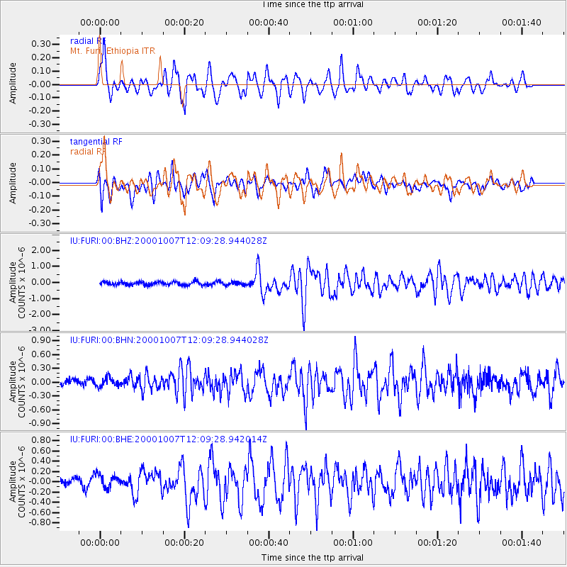
Signal To Noise
| Channel | StoN | STA | LTA |
| IU:FURI:00:BHN:20001007T12:09:28.944028Z | 0.8362472 | 1.2610329E-7 | 1.5079667E-7 |
| IU:FURI:00:BHE:20001007T12:09:28.942014Z | 1.8422972 | 1.298737E-7 | 7.0495524E-8 |
| IU:FURI:00:BHZ:20001007T12:09:28.944028Z | 0.91859716 | 1.01444364E-7 | 1.1043401E-7 |
| Arrivals |
| Ps | 1.3 SECOND |
| PpPs | 5.4 SECOND |
| PsPs/PpSs | 6.7 SECOND |


