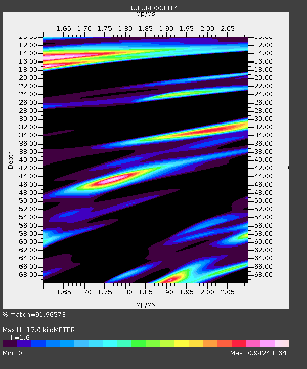
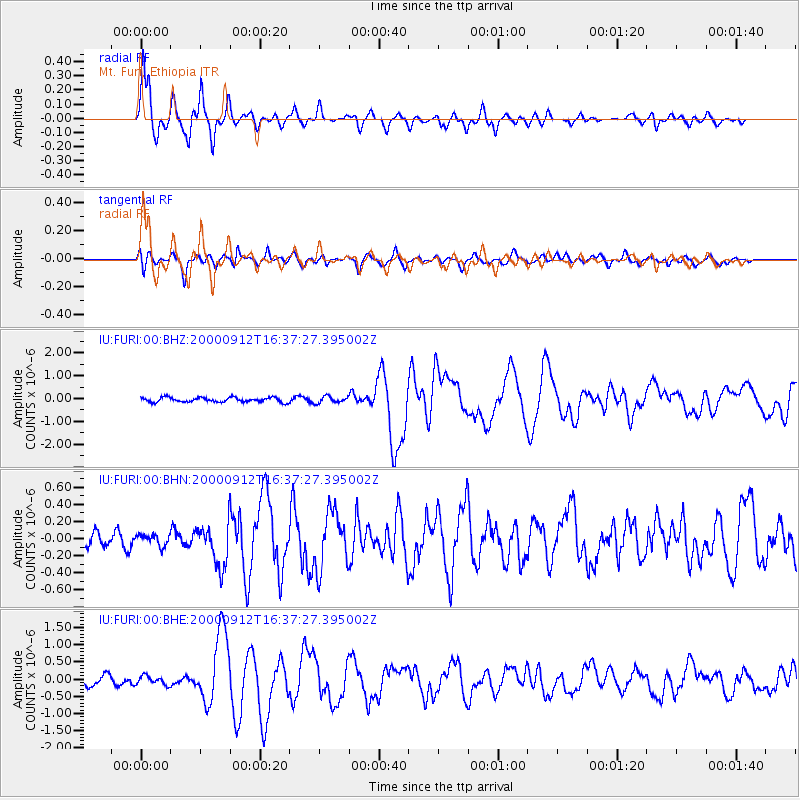
FURI Mt. Furi, Ethiopia - Earthquake Result Viewer

Earthquake location: Southwest Of Sumatra, Indonesia
Earthquake latitude/longitude: -5.4/101.8
Earthquake time(UTC): 2000/09/12 (256) 16:27:24 GMT
Earthquake Depth: 33 km
Earthquake Magnitude: 5.7 MB, 6.1 MS, 6.0 MW, 5.9 MW
Earthquake Catalog/Contributor: WHDF/NEIC
Network: IU Global Seismograph Network (GSN - IRIS/USGS)
Station: FURI Mt. Furi, Ethiopia
Lat/Lon: 8.90 N/38.68 E
Elevation: 2570 m
Distance: 64.5 deg
Az: 282.469 deg
Baz: 100.341 deg
Ray Param: 0.05880788
Estimated Moho Depth: 17.0 km
Estimated Crust Vp/Vs: 1.60
Assumed Crust Vp: 6.464 km/s
Estimated Crust Vs: 4.04 km/s
Estimated Crust Poisson's Ratio: 0.18
Radial Match: 91.96573 %
Radial Bump: 380
Transverse Match: 73.22118 %
Transverse Bump: 400
SOD ConfigId: 3744
Insert Time: 2010-03-03 16:26:08.580 +0000
GWidth: 2.5
Max Bumps: 400
Tol: 0.001

Signal To Noise

ChannelStoNSTALTA
IU:FURI:00:BHN:20000912T16:37:27.395002Z0.53640226.5667436E-81.2242201E-7
IU:FURI:00:BHE:20000912T16:37:27.395002Z1.06649971.2750935E-71.1955872E-7
IU:FURI:00:BHZ:20000912T16:37:27.395002Z1.42863451.431906E-71.00228995E-7
Arrivals
Ps1.7 SECOND
PpPs6.5 SECOND
PsPs/PpSs8.2 SECOND