You are here: Home > Network List > IU - Global Seismograph Network (GSN - IRIS/USGS) Stations List
> Station FURI Mt. Furi, Ethiopia > Earthquake Result Viewer
FURI Mt. Furi, Ethiopia - Earthquake Result Viewer
| Earthquake location: |
South Indian Ocean |
| Earthquake latitude/longitude: |
-13.8/97.5 |
| Earthquake time(UTC): |
2000/06/18 (170) 14:44:13 GMT |
| Earthquake Depth: |
10 km |
| Earthquake Magnitude: |
6.8 MB, 7.8 MS, 7.8 MW, 7.6 MW |
| Earthquake Catalog/Contributor: |
WHDF/NEIC |
|
| Network: |
IU Global Seismograph Network (GSN - IRIS/USGS) |
| Station: |
FURI Mt. Furi, Ethiopia |
| Lat/Lon: |
8.90 N/38.68 E |
| Elevation: |
2570 m |
|
| Distance: |
62.5 deg |
| Az: |
287.762 deg |
| Baz: |
110.561 deg |
| Ray Param: |
0.06016399 |
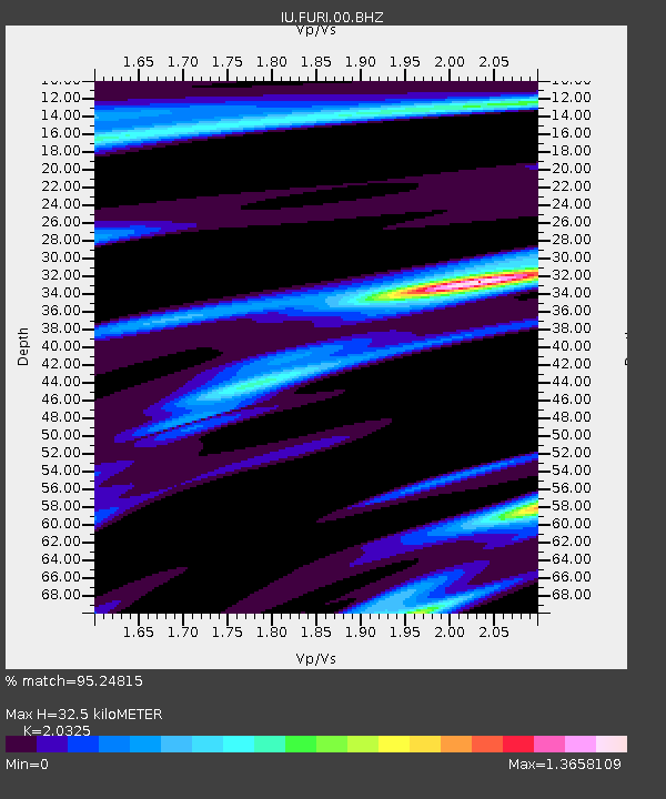
| Estimated Moho Depth: |
32.5 km |
| Estimated Crust Vp/Vs: |
2.03 |
| Assumed Crust Vp: |
6.464 km/s |
| Estimated Crust Vs: |
3.18 km/s |
| Estimated Crust Poisson's Ratio: |
0.34 |
|
| Radial Match: |
95.24815 % |
| Radial Bump: |
373 |
| Transverse Match: |
83.41169 % |
| Transverse Bump: |
400 |
| SOD ConfigId: |
3744 |
| Insert Time: |
2010-03-03 16:26:09.719 +0000 |
| GWidth: |
2.5 |
| Max Bumps: |
400 |
| Tol: |
0.001 |
|
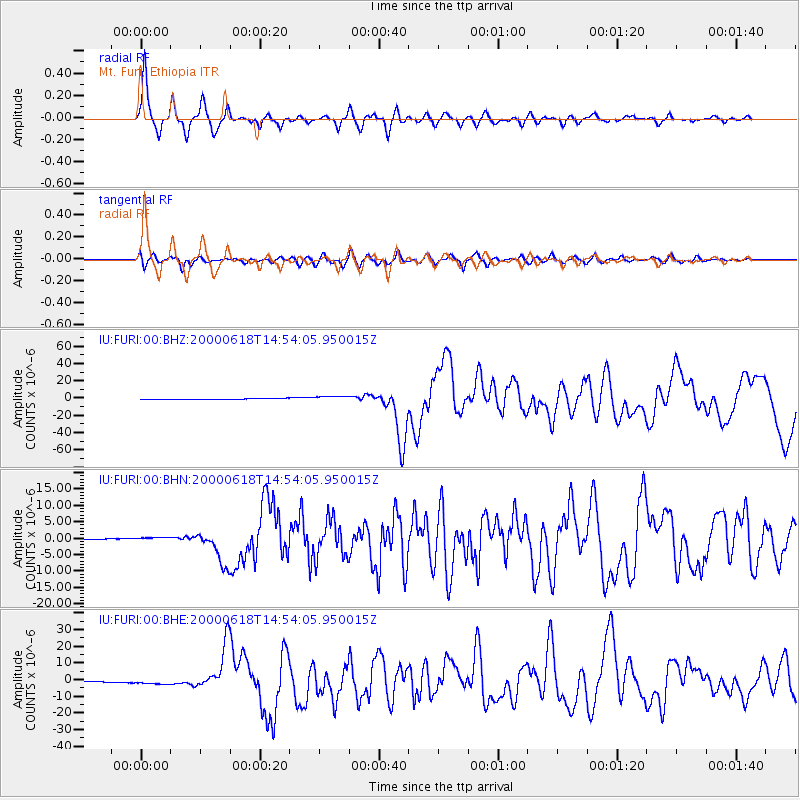
Signal To Noise
| Channel | StoN | STA | LTA |
| IU:FURI:00:BHN:20000618T14:54:05.950015Z | 5.6948357 | 6.17237E-7 | 1.0838539E-7 |
| IU:FURI:00:BHE:20000618T14:54:05.950015Z | 7.0983105 | 1.5125806E-6 | 2.1309023E-7 |
| IU:FURI:00:BHZ:20000618T14:54:05.950015Z | 6.0448875 | 2.9407327E-6 | 4.8648263E-7 |
| Arrivals |
| Ps | 5.4 SECOND |
| PpPs | 15 SECOND |
| PsPs/PpSs | 20 SECOND |


