You are here: Home > Network List > IU - Global Seismograph Network (GSN - IRIS/USGS) Stations List
> Station FURI Mt. Furi, Ethiopia > Earthquake Result Viewer
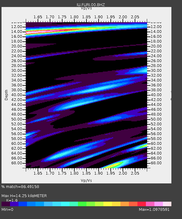
FURI Mt. Furi, Ethiopia - Earthquake Result Viewer
| Earthquake location: |
Taiwan |
| Earthquake latitude/longitude: |
23.8/121.2 |
| Earthquake time(UTC): |
2000/06/10 (162) 18:23:29 GMT |
| Earthquake Depth: |
33 km |
| Earthquake Magnitude: |
6.2 MB, 6.2 MS, 6.4 MW, 6.3 MW |
| Earthquake Catalog/Contributor: |
WHDF/NEIC |
|
| Network: |
IU Global Seismograph Network (GSN - IRIS/USGS) |
| Station: |
FURI Mt. Furi, Ethiopia |
| Lat/Lon: |
8.90 N/38.68 E |
| Elevation: |
2570 m |
|
| Distance: |
79.7 deg |
| Az: |
275.198 deg |
| Baz: |
67.345 deg |
| Ray Param: |
0.048749402 |
| Estimated Moho Depth: |
14.25 km |
| Estimated Crust Vp/Vs: |
1.60 |
| Assumed Crust Vp: |
6.464 km/s |
| Estimated Crust Vs: |
4.04 km/s |
| Estimated Crust Poisson's Ratio: |
0.18 |
|
| Radial Match: |
86.49158 % |
| Radial Bump: |
400 |
| Transverse Match: |
81.62833 % |
| Transverse Bump: |
354 |
| SOD ConfigId: |
3744 |
| Insert Time: |
2010-03-03 16:26:12.720 +0000 |
| GWidth: |
2.5 |
| Max Bumps: |
400 |
| Tol: |
0.001 |
|

Signal To Noise
| Channel | StoN | STA | LTA |
| IU:FURI:00:BHN:20000610T18:35:02.484001Z | 0.68601227 | 9.449123E-8 | 1.3773986E-7 |
| IU:FURI:00:BHE:20000610T18:35:02.484001Z | 1.3755273 | 1.9463805E-7 | 1.4150069E-7 |
| IU:FURI:00:BHZ:20000610T18:35:02.484001Z | 0.529156 | 8.298659E-8 | 1.5682821E-7 |
| Arrivals |
| Ps | 1.4 SECOND |
| PpPs | 5.6 SECOND |
| PsPs/PpSs | 6.9 SECOND |


