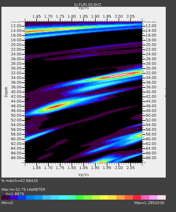
FURI Mt. Furi, Ethiopia - Earthquake Result Viewer
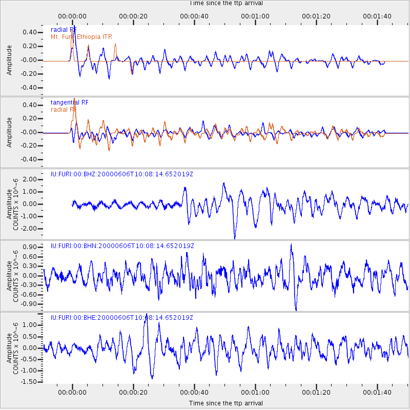
Earthquake location: Southern Sumatra, Indonesia
Earthquake latitude/longitude: -5.1/102.7
Earthquake time(UTC): 2000/06/06 (158) 09:58:06 GMT
Earthquake Depth: 33 km
Earthquake Magnitude: 5.8 MB, 6.1 MS, 6.2 MW, 6.1 MW
Earthquake Catalog/Contributor: WHDF/NEIC
Network: IU Global Seismograph Network (GSN - IRIS/USGS)
Station: FURI Mt. Furi, Ethiopia
Lat/Lon: 8.90 N/38.68 E
Elevation: 2570 m
Distance: 65.3 deg
Az: 282.147 deg
Baz: 99.769 deg
Ray Param: 0.058299944
Estimated Moho Depth: 32.75 km
Estimated Crust Vp/Vs: 2.00
Assumed Crust Vp: 6.464 km/s
Estimated Crust Vs: 3.236 km/s
Estimated Crust Poisson's Ratio: 0.33
Radial Match: 82.96434 %
Radial Bump: 312
Transverse Match: 66.5806 %
Transverse Bump: 400
SOD ConfigId: 3744
Insert Time: 2010-03-03 16:26:16.570 +0000
GWidth: 2.5
Max Bumps: 400
Tol: 0.001

Signal To Noise

ChannelStoNSTALTA
IU:FURI:00:BHN:20000606T10:08:14.652019Z0.817643641.9584736E-72.3952654E-7
IU:FURI:00:BHE:20000606T10:08:14.652019Z0.84608951.3616E-71.6092861E-7
IU:FURI:00:BHZ:20000606T10:08:14.652019Z1.00131481.7705048E-71.7681802E-7
Arrivals
Ps5.2 SECOND
PpPs15 SECOND
PsPs/PpSs20 SECOND