You are here: Home > Network List > IU - Global Seismograph Network (GSN - IRIS/USGS) Stations List
> Station FURI Mt. Furi, Ethiopia > Earthquake Result Viewer
FURI Mt. Furi, Ethiopia - Earthquake Result Viewer
| Earthquake location: |
Turkey |
| Earthquake latitude/longitude: |
38.5/31.4 |
| Earthquake time(UTC): |
2000/12/15 (350) 16:44:47 GMT |
| Earthquake Depth: |
10 km |
| Earthquake Magnitude: |
5.1 MB, 5.8 MS, 6.1 MW, 5.8 MD |
| Earthquake Catalog/Contributor: |
WHDF/NEIC |
|
| Network: |
IU Global Seismograph Network (GSN - IRIS/USGS) |
| Station: |
FURI Mt. Furi, Ethiopia |
| Lat/Lon: |
8.90 N/38.68 E |
| Elevation: |
2570 m |
|
| Distance: |
30.2 deg |
| Az: |
165.472 deg |
| Baz: |
348.503 deg |
| Ray Param: |
0.07940409 |
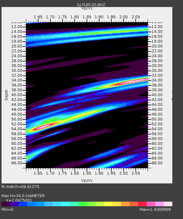
| Estimated Moho Depth: |
34.0 km |
| Estimated Crust Vp/Vs: |
2.05 |
| Assumed Crust Vp: |
6.464 km/s |
| Estimated Crust Vs: |
3.157 km/s |
| Estimated Crust Poisson's Ratio: |
0.34 |
|
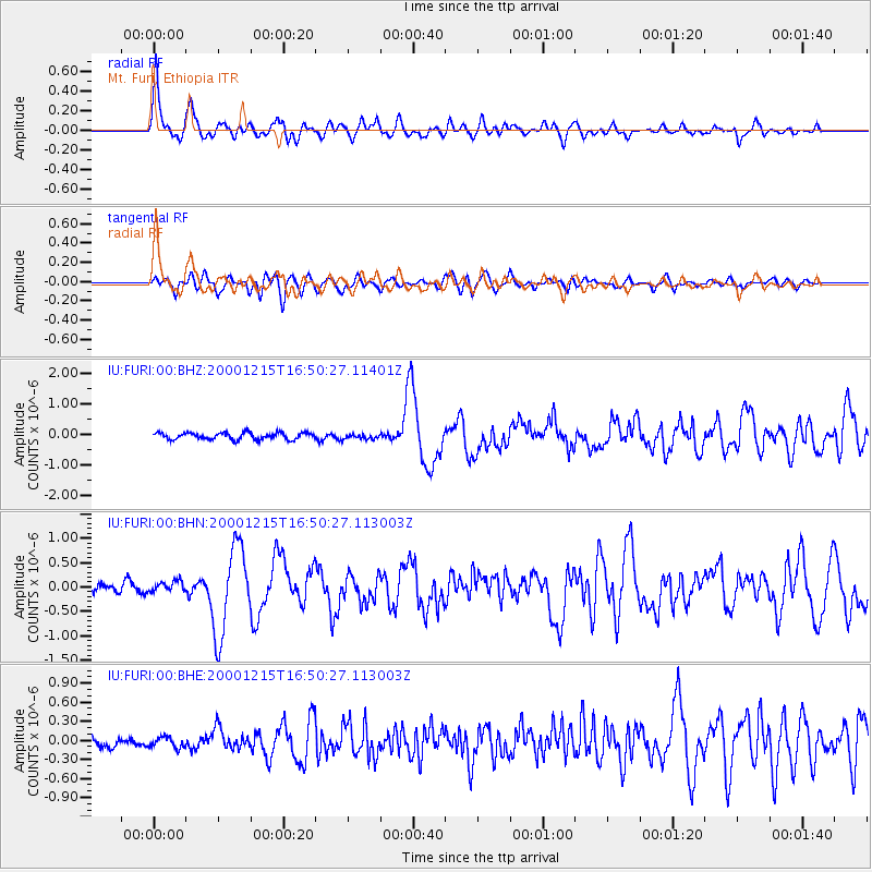
| Radial Match: |
86.61075 % |
| Radial Bump: |
400 |
| Transverse Match: |
69.47744 % |
| Transverse Bump: |
400 |
| SOD ConfigId: |
3744 |
| Insert Time: |
2010-03-03 16:26:24.873 +0000 |
| GWidth: |
2.5 |
| Max Bumps: |
400 |
| Tol: |
0.001 |
|
Signal To Noise
| Channel | StoN | STA | LTA |
| IU:FURI:00:BHN:20001215T16:50:27.113003Z | 1.3341005 | 1.07895204E-7 | 8.087487E-8 |
| IU:FURI:00:BHE:20001215T16:50:27.113003Z | 0.84070927 | 8.265543E-8 | 9.831631E-8 |
| IU:FURI:00:BHZ:20001215T16:50:27.11401Z | 0.7223864 | 8.078585E-8 | 1.11831916E-7 |
| Arrivals |
| Ps | 5.9 SECOND |
| PpPs | 15 SECOND |
| PsPs/PpSs | 21 SECOND |


