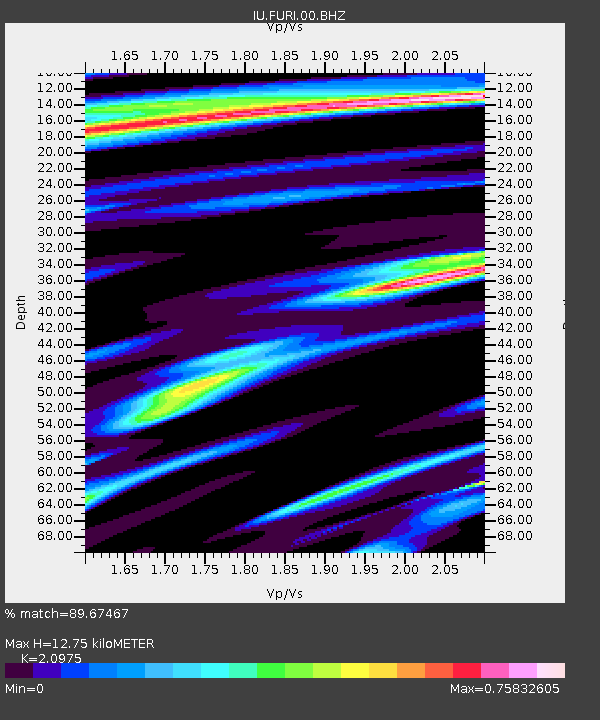
FURI Mt. Furi, Ethiopia - Earthquake Result Viewer

Earthquake location: Northern Mid-Atlantic Ridge
Earthquake latitude/longitude: 31.7/-41.0
Earthquake time(UTC): 2000/10/05 (279) 13:39:11 GMT
Earthquake Depth: 10 km
Earthquake Magnitude: 5.4 MB, 6.1 MS, 6.0 MW, 5.9 MW
Earthquake Catalog/Contributor: WHDF/NEIC
Network: IU Global Seismograph Network (GSN - IRIS/USGS)
Station: FURI Mt. Furi, Ethiopia
Lat/Lon: 8.90 N/38.68 E
Elevation: 2570 m
Distance: 76.6 deg
Az: 87.769 deg
Baz: 300.495 deg
Ray Param: 0.050889418
Estimated Moho Depth: 12.75 km
Estimated Crust Vp/Vs: 2.10
Assumed Crust Vp: 6.464 km/s
Estimated Crust Vs: 3.082 km/s
Estimated Crust Poisson's Ratio: 0.35
Radial Match: 89.67467 %
Radial Bump: 363
Transverse Match: 79.57907 %
Transverse Bump: 400
SOD ConfigId: 3744
Insert Time: 2010-03-03 16:26:28.791 +0000
GWidth: 2.5
Max Bumps: 400
Tol: 0.001

Signal To Noise

ChannelStoNSTALTA
IU:FURI:00:BHN:20001005T13:50:30.932024Z1.54763291.7649222E-71.1404011E-7
IU:FURI:00:BHE:20001005T13:50:30.93001Z0.978957061.01050155E-71.03222256E-7
IU:FURI:00:BHZ:20001005T13:50:30.932024Z0.80222959.507638E-81.1851519E-7
Arrivals
Ps2.2 SECOND
PpPs5.9 SECOND
PsPs/PpSs8.2 SECOND