You are here: Home > Network List > IU - Global Seismograph Network (GSN - IRIS/USGS) Stations List
> Station FURI Mt. Furi, Ethiopia > Earthquake Result Viewer
FURI Mt. Furi, Ethiopia - Earthquake Result Viewer

| Earthquake location: |
Mindanao, Philippines |
| Earthquake latitude/longitude: |
6.9/126.6 |
| Earthquake time(UTC): |
2001/01/01 (001) 06:57:04 GMT |
| Earthquake Depth: |
33 km |
| Earthquake Magnitude: |
6.4 MB, 7.2 MS, 7.5 MW, 7.3 ME |
| Earthquake Catalog/Contributor: |
WHDF/NEIC |
|
| Network: |
IU Global Seismograph Network (GSN - IRIS/USGS) |
| Station: |
FURI Mt. Furi, Ethiopia |
| Lat/Lon: |
8.90 N/38.68 E |
| Elevation: |
2570 m |
|
| Distance: |
86.9 deg |
| Az: |
278.535 deg |
| Baz: |
83.542 deg |
| Ray Param: |
0.043680597 |
| Estimated Moho Depth: |
31.5 km |
| Estimated Crust Vp/Vs: |
1.98 |
| Assumed Crust Vp: |
6.464 km/s |
| Estimated Crust Vs: |
3.264 km/s |
| Estimated Crust Poisson's Ratio: |
0.33 |
|
| Radial Match: |
84.7082 % |
| Radial Bump: |
369 |
| Transverse Match: |
83.10954 % |
| Transverse Bump: |
400 |
| SOD ConfigId: |
3744 |
| Insert Time: |
2010-03-03 16:26:50.255 +0000 |
| GWidth: |
2.5 |
| Max Bumps: |
400 |
| Tol: |
0.001 |
|
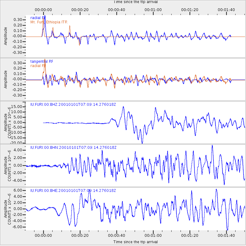
Signal To Noise
| Channel | StoN | STA | LTA |
| IU:FURI:00:BHN:20010101T07:09:14.276018Z | 0.8695387 | 1.2853204E-7 | 1.4781635E-7 |
| IU:FURI:00:BHE:20010101T07:09:14.276018Z | 1.5740114 | 3.4417053E-7 | 2.1865822E-7 |
| IU:FURI:00:BHZ:20010101T07:09:14.276018Z | 1.678895 | 4.1295183E-7 | 2.4596645E-7 |
| Arrivals |
| Ps | 4.9 SECOND |
| PpPs | 14 SECOND |
| PsPs/PpSs | 19 SECOND |


