You are here: Home > Network List > GT - Global Telemetered Seismograph Network (USAF/USGS) Stations List
> Station LPAZ La Paz , Bolivia > Earthquake Result Viewer
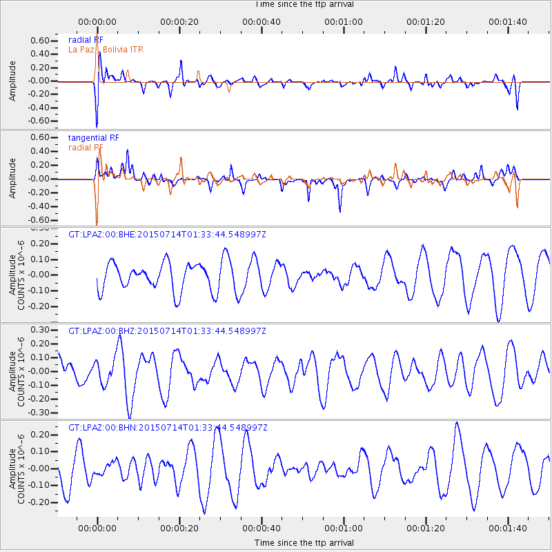
LPAZ La Paz , Bolivia - Earthquake Result Viewer
*The percent match for this event was below the threshold and hence no stack was calculated.
| Earthquake location: |
Near Coast Of Michoacan, Mexico |
| Earthquake latitude/longitude: |
18.2/-103.5 |
| Earthquake time(UTC): |
2015/07/14 (195) 01:25:30 GMT |
| Earthquake Depth: |
14 km |
| Earthquake Magnitude: |
4.9 MW |
| Earthquake Catalog/Contributor: |
ISC/ISC |
|
| Network: |
GT Global Telemetered Seismograph Network (USAF/USGS) |
| Station: |
LPAZ La Paz , Bolivia |
| Lat/Lon: |
16.29 S/68.13 W |
| Elevation: |
4769 m |
|
| Distance: |
48.8 deg |
| Az: |
132.455 deg |
| Baz: |
313.091 deg |
| Ray Param: |
$rayparam |
*The percent match for this event was below the threshold and hence was not used in the summary stack. |
|
| Radial Match: |
51.462578 % |
| Radial Bump: |
400 |
| Transverse Match: |
68.83038 % |
| Transverse Bump: |
400 |
| SOD ConfigId: |
7422571 |
| Insert Time: |
2019-04-19 19:23:24.474 +0000 |
| GWidth: |
2.5 |
| Max Bumps: |
400 |
| Tol: |
0.001 |
|
Signal To Noise
| Channel | StoN | STA | LTA |
| GT:LPAZ:00:BHZ:20150714T01:33:44.548997Z | 0.70866156 | 8.9559016E-8 | 1.263777E-7 |
| GT:LPAZ:00:BHN:20150714T01:33:44.548997Z | 0.27797303 | 3.910489E-8 | 1.4067872E-7 |
| GT:LPAZ:00:BHE:20150714T01:33:44.548997Z | 1.5483077 | 1.2625652E-7 | 8.1544854E-8 |
| Arrivals |
| Ps | |
| PpPs | |
| PsPs/PpSs | |


