You are here: Home > Network List > IU - Global Seismograph Network (GSN - IRIS/USGS) Stations List
> Station FURI Mt. Furi, Ethiopia > Earthquake Result Viewer
FURI Mt. Furi, Ethiopia - Earthquake Result Viewer
| Earthquake location: |
Minahassa Peninsula, Sulawesi |
| Earthquake latitude/longitude: |
0.5/121.9 |
| Earthquake time(UTC): |
2001/03/14 (073) 18:56:18 GMT |
| Earthquake Depth: |
109 km |
| Earthquake Magnitude: |
5.9 MB, 6.0 MW, 5.9 MW |
| Earthquake Catalog/Contributor: |
WHDF/NEIC |
|
| Network: |
IU Global Seismograph Network (GSN - IRIS/USGS) |
| Station: |
FURI Mt. Furi, Ethiopia |
| Lat/Lon: |
8.90 N/38.68 E |
| Elevation: |
2570 m |
|
| Distance: |
83.2 deg |
| Az: |
278.846 deg |
| Baz: |
90.602 deg |
| Ray Param: |
0.046097342 |
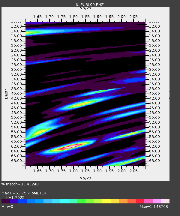
| Estimated Moho Depth: |
61.75 km |
| Estimated Crust Vp/Vs: |
1.79 |
| Assumed Crust Vp: |
6.464 km/s |
| Estimated Crust Vs: |
3.606 km/s |
| Estimated Crust Poisson's Ratio: |
0.27 |
|
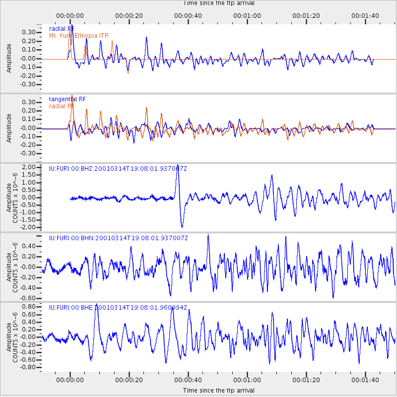
| Radial Match: |
83.43248 % |
| Radial Bump: |
400 |
| Transverse Match: |
68.86811 % |
| Transverse Bump: |
400 |
| SOD ConfigId: |
3744 |
| Insert Time: |
2010-03-03 16:26:53.143 +0000 |
| GWidth: |
2.5 |
| Max Bumps: |
400 |
| Tol: |
0.001 |
|
Signal To Noise
| Channel | StoN | STA | LTA |
| IU:FURI:00:BHN:20010314T19:08:01.937007Z | 0.8552196 | 8.375669E-8 | 9.793588E-8 |
| IU:FURI:00:BHE:20010314T19:08:01.960994Z | 1.2824455 | 8.738185E-8 | 6.813689E-8 |
| IU:FURI:00:BHZ:20010314T19:08:01.937007Z | 0.8410654 | 6.4763626E-8 | 7.700189E-8 |
| Arrivals |
| Ps | 7.8 SECOND |
| PpPs | 26 SECOND |
| PsPs/PpSs | 34 SECOND |


