You are here: Home > Network List > IU - Global Seismograph Network (GSN - IRIS/USGS) Stations List
> Station FURI Mt. Furi, Ethiopia > Earthquake Result Viewer
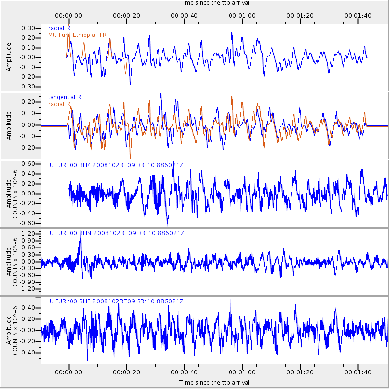
FURI Mt. Furi, Ethiopia - Earthquake Result Viewer
*The percent match for this event was below the threshold and hence no stack was calculated.
| Earthquake location: |
Mindanao, Philippines |
| Earthquake latitude/longitude: |
6.0/125.8 |
| Earthquake time(UTC): |
2008/10/23 (297) 09:21:15 GMT |
| Earthquake Depth: |
130 km |
| Earthquake Magnitude: |
5.8 MB, 5.7 MW, 5.6 MW |
| Earthquake Catalog/Contributor: |
WHDF/NEIC |
|
| Network: |
IU Global Seismograph Network (GSN - IRIS/USGS) |
| Station: |
FURI Mt. Furi, Ethiopia |
| Lat/Lon: |
8.90 N/38.68 E |
| Elevation: |
2570 m |
|
| Distance: |
86.2 deg |
| Az: |
278.509 deg |
| Baz: |
84.587 deg |
| Ray Param: |
$rayparam |
*The percent match for this event was below the threshold and hence was not used in the summary stack. |
|
| Radial Match: |
50.78262 % |
| Radial Bump: |
400 |
| Transverse Match: |
54.89869 % |
| Transverse Bump: |
400 |
| SOD ConfigId: |
2556 |
| Insert Time: |
2010-03-03 16:26:58.538 +0000 |
| GWidth: |
2.5 |
| Max Bumps: |
400 |
| Tol: |
0.001 |
|
Signal To Noise
| Channel | StoN | STA | LTA |
| IU:FURI:00:BHN:20081023T09:33:10.886021Z | 2.8747952 | 4.0936828E-7 | 1.4239912E-7 |
| IU:FURI:00:BHE:20081023T09:33:10.886021Z | 0.96535605 | 1.291649E-7 | 1.3380027E-7 |
| IU:FURI:00:BHZ:20081023T09:33:10.886021Z | 2.0715234 | 2.8738233E-7 | 1.3872994E-7 |
| Arrivals |
| Ps | |
| PpPs | |
| PsPs/PpSs | |


