You are here: Home > Network List > IU - Global Seismograph Network (GSN - IRIS/USGS) Stations List
> Station FURI Mt. Furi, Ethiopia > Earthquake Result Viewer
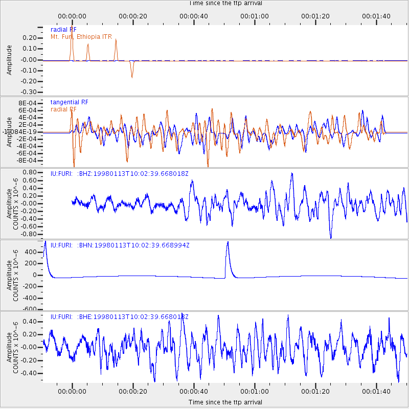
FURI Mt. Furi, Ethiopia - Earthquake Result Viewer
*The percent match for this event was below the threshold and hence no stack was calculated.
| Earthquake location: |
Banda Sea |
| Earthquake latitude/longitude: |
-4.1/129.1 |
| Earthquake time(UTC): |
1998/01/13 (013) 09:50:11 GMT |
| Earthquake Depth: |
44 km |
| Earthquake Magnitude: |
5.9 MB, 5.5 MS, 5.9 UNKNOWN, 5.8 MW |
| Earthquake Catalog/Contributor: |
WHDF/NEIC |
|
| Network: |
IU Global Seismograph Network (GSN - IRIS/USGS) |
| Station: |
FURI Mt. Furi, Ethiopia |
| Lat/Lon: |
8.90 N/38.68 E |
| Elevation: |
2570 m |
|
| Distance: |
91.1 deg |
| Az: |
278.785 deg |
| Baz: |
93.957 deg |
| Ray Param: |
$rayparam |
*The percent match for this event was below the threshold and hence was not used in the summary stack. |
|
| Radial Match: |
46.17409 % |
| Radial Bump: |
400 |
| Transverse Match: |
48.529926 % |
| Transverse Bump: |
400 |
| SOD ConfigId: |
4480 |
| Insert Time: |
2010-03-03 16:27:01.269 +0000 |
| GWidth: |
2.5 |
| Max Bumps: |
400 |
| Tol: |
0.001 |
|
Signal To Noise
| Channel | StoN | STA | LTA |
| IU:FURI: :BHN:19980113T10:02:39.668994Z | 0.27904508 | 3.196682E-5 | 1.14557915E-4 |
| IU:FURI: :BHE:19980113T10:02:39.668018Z | 0.945292 | 1.26512E-7 | 1.338338E-7 |
| IU:FURI: :BHZ:19980113T10:02:39.668018Z | 1.2138959 | 1.2095825E-7 | 9.9644666E-8 |
| Arrivals |
| Ps | |
| PpPs | |
| PsPs/PpSs | |


