You are here: Home > Network List > UW - Pacific Northwest Regional Seismic Network Stations List
> Station LCCR Mulino, OR, USA > Earthquake Result Viewer
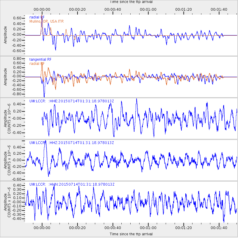
LCCR Mulino, OR, USA - Earthquake Result Viewer
*The percent match for this event was below the threshold and hence no stack was calculated.
| Earthquake location: |
Near Coast Of Michoacan, Mexico |
| Earthquake latitude/longitude: |
18.2/-103.5 |
| Earthquake time(UTC): |
2015/07/14 (195) 01:25:30 GMT |
| Earthquake Depth: |
14 km |
| Earthquake Magnitude: |
4.9 MW |
| Earthquake Catalog/Contributor: |
ISC/ISC |
|
| Network: |
UW Pacific Northwest Regional Seismic Network |
| Station: |
LCCR Mulino, OR, USA |
| Lat/Lon: |
45.21 N/122.48 W |
| Elevation: |
273 m |
|
| Distance: |
31.2 deg |
| Az: |
333.645 deg |
| Baz: |
143.351 deg |
| Ray Param: |
$rayparam |
*The percent match for this event was below the threshold and hence was not used in the summary stack. |
|
| Radial Match: |
62.829033 % |
| Radial Bump: |
400 |
| Transverse Match: |
53.5722 % |
| Transverse Bump: |
400 |
| SOD ConfigId: |
7422571 |
| Insert Time: |
2019-04-19 19:25:26.312 +0000 |
| GWidth: |
2.5 |
| Max Bumps: |
400 |
| Tol: |
0.001 |
|
Signal To Noise
| Channel | StoN | STA | LTA |
| UW:LCCR: :HHZ:20150714T01:31:18.978013Z | 3.4380748 | 3.4733614E-7 | 1.0102635E-7 |
| UW:LCCR: :HHN:20150714T01:31:18.978013Z | 1.4032546 | 2.0978922E-7 | 1.495019E-7 |
| UW:LCCR: :HHE:20150714T01:31:18.978013Z | 1.2294856 | 2.114635E-7 | 1.7199348E-7 |
| Arrivals |
| Ps | |
| PpPs | |
| PsPs/PpSs | |


