You are here: Home > Network List > IU - Global Seismograph Network (GSN - IRIS/USGS) Stations List
> Station FURI Mt. Furi, Ethiopia > Earthquake Result Viewer
FURI Mt. Furi, Ethiopia - Earthquake Result Viewer
*The percent match for this event was below the threshold and hence no stack was calculated.
| Earthquake location: |
Hokkaido, Japan Region |
| Earthquake latitude/longitude: |
41.5/142.0 |
| Earthquake time(UTC): |
2008/04/29 (120) 05:26:04 GMT |
| Earthquake Depth: |
47 km |
| Earthquake Magnitude: |
5.5 MB, 5.2 MS, 5.8 MW, 5.8 MW |
| Earthquake Catalog/Contributor: |
WHDF/NEIC |
|
| Network: |
IU Global Seismograph Network (GSN - IRIS/USGS) |
| Station: |
FURI Mt. Furi, Ethiopia |
| Lat/Lon: |
8.90 N/38.68 E |
| Elevation: |
2570 m |
|
| Distance: |
94.0 deg |
| Az: |
285.462 deg |
| Baz: |
47.156 deg |
| Ray Param: |
$rayparam |
*The percent match for this event was below the threshold and hence was not used in the summary stack. |
|
| Radial Match: |
68.26854 % |
| Radial Bump: |
400 |
| Transverse Match: |
63.338406 % |
| Transverse Bump: |
400 |
| SOD ConfigId: |
2504 |
| Insert Time: |
2010-03-03 16:27:10.086 +0000 |
| GWidth: |
2.5 |
| Max Bumps: |
400 |
| Tol: |
0.001 |
|
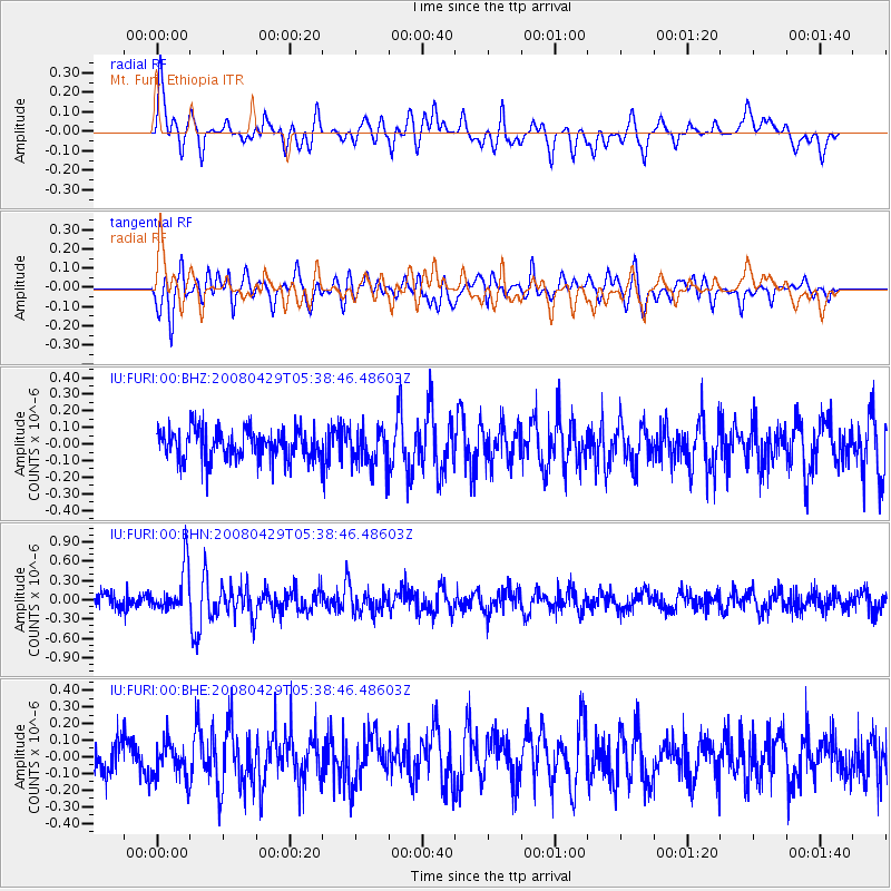
Signal To Noise
| Channel | StoN | STA | LTA |
| IU:FURI:00:BHN:20080429T05:38:46.48603Z | 3.1500592 | 3.4158006E-7 | 1.0843607E-7 |
| IU:FURI:00:BHE:20080429T05:38:46.48603Z | 0.91520876 | 1.0744497E-7 | 1.1739941E-7 |
| IU:FURI:00:BHZ:20080429T05:38:46.48603Z | 1.1874895 | 1.1241733E-7 | 9.466807E-8 |
| Arrivals |
| Ps | |
| PpPs | |
| PsPs/PpSs | |


