You are here: Home > Network List > IU - Global Seismograph Network (GSN - IRIS/USGS) Stations List
> Station FURI Mt. Furi, Ethiopia > Earthquake Result Viewer
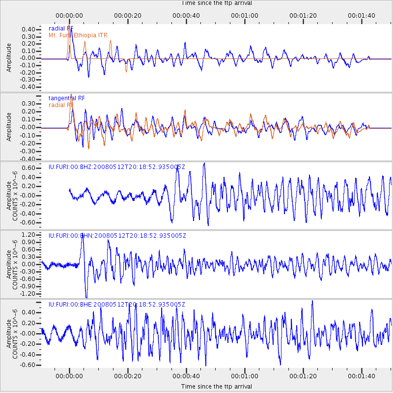
FURI Mt. Furi, Ethiopia - Earthquake Result Viewer
*The percent match for this event was below the threshold and hence no stack was calculated.
| Earthquake location: |
Sichuan, China |
| Earthquake latitude/longitude: |
31.4/103.9 |
| Earthquake time(UTC): |
2008/05/12 (133) 20:08:50 GMT |
| Earthquake Depth: |
22 km |
| Earthquake Magnitude: |
5.7 MB, 5.5 MS, 5.6 MW, 5.5 MW |
| Earthquake Catalog/Contributor: |
WHDF/NEIC |
|
| Network: |
IU Global Seismograph Network (GSN - IRIS/USGS) |
| Station: |
FURI Mt. Furi, Ethiopia |
| Lat/Lon: |
8.90 N/38.68 E |
| Elevation: |
2570 m |
|
| Distance: |
64.3 deg |
| Az: |
264.679 deg |
| Baz: |
59.488 deg |
| Ray Param: |
$rayparam |
*The percent match for this event was below the threshold and hence was not used in the summary stack. |
|
| Radial Match: |
78.99305 % |
| Radial Bump: |
400 |
| Transverse Match: |
74.10958 % |
| Transverse Bump: |
400 |
| SOD ConfigId: |
2504 |
| Insert Time: |
2010-03-03 16:27:15.769 +0000 |
| GWidth: |
2.5 |
| Max Bumps: |
400 |
| Tol: |
0.001 |
|
Signal To Noise
| Channel | StoN | STA | LTA |
| IU:FURI:00:BHN:20080512T20:18:52.935005Z | 6.567188 | 4.414548E-7 | 6.7221286E-8 |
| IU:FURI:00:BHE:20080512T20:18:52.935005Z | 1.3668796 | 1.1860907E-7 | 8.677361E-8 |
| IU:FURI:00:BHZ:20080512T20:18:52.935005Z | 2.2260306 | 1.7346439E-7 | 7.792543E-8 |
| Arrivals |
| Ps | |
| PpPs | |
| PsPs/PpSs | |


